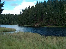
Vogtlandsee
| Vogtlandsee | ||
|---|---|---|

|
||
| Vogtlandsee seen from the top of the dam | ||
| Geographical location | Southeast Saxony |
|
| Tributaries | Red river | |
| Drain | Red river | |
| Location close to the shore | Auerbach / Vogtl. | |
| Data | ||
| Coordinates | 50 ° 27 '48 " N , 12 ° 27' 24" E | |
|
|
||
| Altitude above sea level | 671 m above sea level NHN | |
| surface | 0.06 km² | |
The Vogtlandsee is a small forest lake in the Vogtlandkreis in southwest Saxony . It is located in the middle of a 30 km² forest area, which is bordered by the towns of Beerheide , Schönheide and Morgenröthe-Rautenkranz . In the north of the lake there is an island separated from the shore by a narrow strip of water.
etymology
The name was chosen in 1937 because of its geographical location.
geography
- Size: 6 ha
- Catchment area: 2.5 km²
- Dam crest: 672 m above sea level (HN) 99 m long
- Dam height: 7 m earth dam
- Dammed water: Red River
- River basin: Zwickauer Mulde
- mean annual inflow: 1,000,000 m³
Aquatic ecology
Due to the boggy catchment area, the water is very acidic, so there is no fish population. Many waterfowl use the partly inaccessible bank as breeding ground, e.g. B. Little Grebe (Tachybaptus ruficollis). In the Großseggenried of the silting area, v. a. on the west bank, important habitats of dragonfly species, e.g. B. Little moss damsel (Leucorrhinia dubia).
Emergence
The reservoir was built from 1935 to 1937 for flood protection.
use
Mainly for flood protection and as process water for agriculture and forestry.
tourism
The idyllic lake is a popular destination for hikers, cyclists and, in winter, for cross-country skiers. Due to its hidden location, it is often used as a nudist bathing lake.
Hiking trails and trails
A 3 km long circular path runs around the Vogtlandsee. The forest park circuit also runs not far from the lake. The Vogtland Panorama Weg , the Eisenach-Budapest long-distance hiking trail and some regional paths and cycle paths lead through the forest area surrounding the lake .
The forest park trail (5 km) touches the lake. Over them, the lake is connected to the subsequent skiing: Zinsbach track (7 km), then a trail connecting the Kammloipe (km 36, one of the most snow trails Germany), Skiworld Schöneck , connection trail Aschberg , connection trail Sonnenloipe (4 km) ski resort Muehlleithen , ski resort Johanngeorgenstadt and the Czech ski area Bublava (Schwaderbach).
literature
- Eastern Vogtland Western Ore Mountains Hiking and cycling map 1: 33000, Saxony cartography, ISBN 3-932281-59-4
- Westerzgebirge / Vogtland winter sports map 1: 40000, Saxony cartography, ISBN 978-3-932281-53-2


