
Beerheide
|
Beerheide
Municipality of Auerbach / Vogtl.
Coordinates: 50 ° 28 ′ 41 ″ N , 12 ° 25 ′ 31 ″ E
|
||
|---|---|---|
| Height : | 710 m | |
| Incorporation : | January 1, 1999 | |
| Incorporated into: | Auerbach | |
| Postal code : | 08209 | |
| Area code : | 03744 | |
Location of Beerheide in Saxony |
||


Beerheide is one of the four localities in the city of Auerbach / Vogtl. The municipality Beerheide with the districts High Green and main Brunn was incorporated on 1 January 1999 to Auerbach. By integrating the municipality of Beerheide into the city of Auerbach / Vogtl. they became a town in the town of Auerbach / Vogtl. with its own local council.
Geographical location
location
Beerheide is located north of the Roten Göltzsch , a source arm of the Göltzsch , and in the south of the city of Auerbach / Vogtl. in the east of the natural area Vogtland and in the Saxon part of the historical Vogtland . Southeast of Beerheide, the Vogtlandsee can be reached via the Jägerwiesenweg after a good two kilometers in the direction of Morgenröthe-Rautenkranz, in the middle of a dense forest .
According to the natural space map of Saxony , the village belongs to the mesogeochore "western edge stage of the Ore Mountains near Auerbach" and within these to the microgeochore "Beerheider plateau".
Neighboring places
| Mühlgrün (Auerbach) | Auerbach / Vogtl. | Snarling fir |
| Falkenstein / Vogtl. |
.svg)
|
Grünheide (Auerbach) |
| Grünbach | Hammer bridge | Morgenröthe diamond wreath |
history
The Hohengrün district was first mentioned in 1411 and Hauptbrunn in 1542. The district of Beerheide, which gives the unified community its name, was first mentioned in a document in 1575 in a letter of purchase from the nobles von Planitz . With the division of the Auerbach manor in 1599, Beerheide belonged to the Auerbach manor upper part.
Beerheide belonged to the rule of Auerbach until the 16th century and then until 1856 to the Electoral Saxon or later royal Saxon office of Plauen . In 1856 the place was affiliated with the Auerbach court office and in 1875 with the Auerbach administration . In 1869 Hohengrün, Hauptbrunn and Beerheide formed the unified municipality with the name Beerheide.
As a result of the second district reform in the GDR , the municipality of Beerheide became part of Auerbach in the Chemnitz district (renamed the Karl-Marx-Stadt district in 1953 ), which was continued as the Saxon district of Auerbach in 1990 and became part of the Vogtland district in 1996. On January 1, 1999, the municipality of Beerheide became the major district town of Auerbach / Vogtl. incorporated.
Whitsun singing has been held annually on Röthelstein (Beerheide) , a quartzite rock on the right bank of the Rote Göltzsch, since 1953 . A natural stage was built for this. Since 1967, the community has had the title of "State Recognized Resort".

Rock from the natural stage

Natural stage
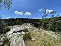
platform

Rock up close
_01.jpg)
_02.jpg)
_03.jpg)
_04.jpg)
literature
- Albert Schiffner : Handbook of geography, statistics and topography of the Kingdom of Saxony. First delivery, containing the Zwickau directions district , from Friedrich Fleischer, Leipzig 1839, p. 377 ( link to digitized version )
- The eastern Vogtland (= values of the German homeland . Volume 59). 1st edition. Verlag Hermann Böhlaus Successor, Weimar 1998, ISBN 3-7400-0938-1 , pp. 153-155.
Web links
- Beerheide in the Digital Historical Directory of Saxony
- Website of the Gemeine Beerheide
Individual evidence
- ↑ Natural space map service of the Landschaftsforschungszentrum eV Dresden ( information )
- ↑ Beerheide on the website of the municipality
- ^ Karlheinz Blaschke , Uwe Ulrich Jäschke : Kursächsischer Ämteratlas. Leipzig 2009, ISBN 978-3-937386-14-0 ; P. 76 f.
- ^ The Auerbach administration in the municipality register 1900
- ↑ Beerheide on gov.genealogy.net

Auerbach / Vogtl. | Bad Reiboldsgrün | Beerheide | Brunn | Georgengrün | Grünheide | Haideschachen | Hauptbrunn | Hohengrün | Mill green | Vine green | Rempes green | Reumtengrün | Sniffing fir | Sorga | Bird green | Zöbisch