Auerbach / Vogtl.
| coat of arms | Germany map | |
|---|---|---|

|
Coordinates: 50 ° 31 ' N , 12 ° 24' E |
|
| Basic data | ||
| State : | Saxony | |
| County : | Vogtland district | |
| Height : | 555 m above sea level NHN | |
| Area : | 55.52 km 2 | |
| Residents: | 18,237 (Dec. 31, 2019) | |
| Population density : | 328 inhabitants per km 2 | |
| Postal code : | 08209 | |
| Area code : | 03744 | |
| License plate : | V, AE, OVL, PL, RC | |
| Community key : | 14 5 23 020 | |
| City structure: | Core city; 4 localities | |
City administration address : |
Nicolaistraße 51 08209 Auerbach / Vogtl. |
|
| Website : | ||
| Lord Mayor : | Manfred Deckert (independent) | |
| Location of the city of Auerbach / Vogtl. in the Vogtland district | ||


The large district town of Auerbach / Vogtl. is a city in the Saxon Vogtlandkreis . It is considered the center of the eastern Vogtland and is the third largest city in the district after Plauen and Reichenbach in the Vogtland .
geography
Geographical location
Auerbach is located in the Saxon Vogtland and is cut through by the Göltzsch river . The landscape of Auerbach is in the German low mountain range , in the immediate vicinity of the Ore Mountains in the east. Auerbach is 17 kilometers from Reichenbach , 27 kilometers from Plauen and 28 kilometers from Zwickau .
Neighboring communities
Adjacent communities are Ellefeld , Falkenstein / Vogtl. (City), Muldenhammer , Rodewisch (city), and Treuen (city) in the Vogtland district and Schönheide in the Ore Mountains district . The city of Auerbach and the neighboring communities of Falkenstein, Rodewisch and Ellefeld form the Göltzschtal central city association.
City structure
The city of Auerbach includes the core city:
- the four localities
- Beerheide
- Vine green
- Reumtengrün
- Snarling fir with the cockhouses
- the districts
|
|
|
|
The towns of Beerheide and Schnarrtanne are state-recognized recreational areas. In Schnarrtanne existed for GDR -time the holiday home of the Reichsbahn repair shop '7. October “Zwickau, the company holiday camp“ Rolf Weinbrecht ”and the Gardelko holiday home in the restaurant“ Goldene Höhe ”, which was demolished in 2014, in Brunn that of the wholesale WtB Kombinat Berlin, formerly also called the holiday home of the GHG Berlin, in Vogelsgrün the holiday home of the VEB Nema in Netzschkau and the FDGB children's health home “Be ready”. During the GDR era, Grünheide had a children's recreation and spa home called “Friendship” and the “Wladimir Mayakowski” pioneer camp . In the latter there were tents. At the beginning of the 1970s, 14-day courses were held in the home and tent camps, together with a capacity of around 650 people, in preparation for studying. In Hohengrün there was a vacation home of the “VEB MLW Prüfgerätewerk Medingen, Freital headquarters” during the GDR era.
history
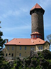
Auerbach was first mentioned in a document in 1282 in connection with Conradus de Urbach . The castle itself was first mentioned in 1122 and was built in the 11th century. A remnant of it is the castle tower . The medieval city with a grid-shaped floor plan was planned in the 14th century by the bailiffs of Plauen . The citizens were enfeoffed with brewing beer by the bailiff in 1436. In the 15th century, Hans Edler von der Planitz owned the Auerbach manor. His heirs subsequently took over the property. In 1755, Karl Gottlob Dietmann named Karl Friedrich Edler von der Planitz in “Priesthood in the Electorate of Saxony” as the lord in Auerbach. Tin and iron ore mining developed. In 1503 Auerbach received a mining authority and in 1543 it became a mining town. Since there were now pitch unions and pitch huts, Auerbach was given the nickname “Pechstadt” in the 17th century. The current spelling of the place name finally prevailed in 1578, previous forms were: Urbach, Uwerbach, Awerboch and Awherbach. Auerbach belonged to the Plauen Office until the 19th century and then to the Auerbach Office .
Until 1995 Auerbach was the district town of the district of the same name .
Incorporations
| Former parish | date | annotation |
|---|---|---|
| Beerheide | 01/01/1999 | with Hohengrün and Hauptbrunn |
| Well | 07/01/1950 | with dressel green |
| Mill green | 01/01/1912 | |
| Vine green | 01/01/2003 | |
| Rempes green | 10/01/1923 | |
| Reumtengrün | 01/01/1994 | Incorporation after Rebesgrün |
| Snarling fir | 01/01/1994 | with Grünheide and Bad Reiboldsgrün |
| Sorga with a back grove | 10/01/1923 | |
| Bird green | 07/01/1950 | Incorporation after Schnarrtanne |
coat of arms
Description : In black an upright golden lion.
The coat of arms with the lion as heraldic animal was awarded to the city by the bailiffs of Plauen around 1400. These were the lords of Urbach Castle and owners of large, wooded lands in the region . The city has had the coat of arms for centuries.
Population development
Development of the population (from 1960 December 31) :
1834 to 1960
|
1971 to 2008
|
from 2012
|
Data source from 1998: State Statistical Office Saxony
1 October 29th
2 August 31st
politics
City council
After the municipal council election on May 25, 2014 , the 22 seats of the city council were distributed among the individual groups as follows:
- CDU : 11 seats
- SPD : 4 seats
- LEFT : 4 seats
- FDP : 1 seat
- VfB 1906 Auerbach e. V. (VfB): 1 seat
- Free Electoral Association Auerbach (FW AE): 1 seat
The distribution of seats after the city council election on May 26, 2019 is shown in the diagram opposite.
mayor
Manfred Deckert was re-elected in June 2015.
Town twinning
Culture and sights
Auerbach also bears the name "Three Towers City". If you look at Auerbach from further away in the night, you can see three brightly lit towers. On the one hand, there is the castle tower , which has shaped the city skyline for over 725 years . The other two towers are the Catholic Church "Zum Heiligen Kreuz" on the Catholic Mountain and the Protestant Church "St. Laurentius ”on the Altmarkt.
Actually it should be called the city of four towers, because there are three churches and the castle tower in Auerbach, but since the tower of the "Nicolaikirche" is not visible from a distance due to its small size, Auerbach was named a "city of three towers" known.
In the district of Brunn is the " Waldbad Brunn ", which was built in 1925 and reopened at the beginning of the 2008 season.
Memorials
- Oak cross on the municipal cemetery for the victims of fascism , with the grave of an unknown concentration camp prisoner who was murdered by SS men on a death march from one of the subcamps of the Flossenbürg concentration camp
- Tombs in the cemetery for 28 (including 18 known by name) Soviet men and women during the Second World War deported to Germany and victims of forced labor were
- Memorial from 1995 for the victims of forced labor in Eisenbahnstraße as a replacement for the memorial for the victims of fascism that was razed in 1990 by the mayor at the time
- see also the list of stumbling blocks in Auerbach / Vogtl.
Sports
The VfB Auerbach was founded in 1906 and re-founded 1991st The football department plays in the Regionalliga Nordost (2014/2015).
Regular events
Every year in August, the Altmarktfest takes place, a medieval spectacle that is well-known beyond the town.
Infrastructure and economy
traffic
The Auerbach airfield is located in Auerbach . There are two train stations and one stop that are served by the Vogtlandbahn . From the top station on the railway line Herlasgrün-Oelsnitz can Plauen , Hof , Falkenstein and Adorf be achieved. From the lower station on the railway line Zwickau-Falkenstein are Zwickau , Falkenstein and Klingenthal distance. The line that runs through the lower station was extended to the Czech Republic in 2000. This means that in the Czech border town of Kraslice there is a possibility of changing trains to GW Train Regio ; Sokolov and Karlovy Vary (Karlovy Vary - connection only on weekends) can be reached directly with a connection to the express train network of the Czech railway company České dráhy .
Since 2018, there has been a station at the garden house in Auerbach for the central German car sharing provider Teilauto , where two electric cars are available for hire. This z. B. Tourists without their own car arrive by train and use a partial car for remote destinations in the area. Auerbach can be seen as a pioneer in this sense, because it is one of the very few small towns that have a car sharing station, while such offers are mostly limited to large metropolitan areas.
Established businesses
The city's important economic sectors are the textile industry, with companies such as manufacturers of textiles for weather protection, work clothing services and embroidered textiles, the food industry, the electrical and automotive supply industry and machine tool construction.
Personalities
literature
- Richard Steche : Auerbach. In: Descriptive representation of the older architectural and art monuments of the Kingdom of Saxony. 9th booklet: Auerbach District Authority . CC Meinhold, Dresden 1888, p. 3.
- The eastern Vogtland (= values of the German homeland . Volume 59). 1st edition. Verlag Hermann Böhlaus successor, Weimar 1998, ISBN 3-7400-0938-1 .
Web links
- Web presence of the city of Auerbach
- Auerbach / Vogtl. in the digital historical directory of Saxony
Individual evidence
- ↑ Population of the Free State of Saxony by municipalities on December 31, 2019 ( help on this ).
- ↑ vogtlandkreis.de: Localities ( Memento of 12 March 2009 at the Internet Archive )
- ↑ Announcement of the Saxon State Ministry for Economics, Labor and Transport on the change of the list of health resorts and recreation places in the Free State of Saxony according to § 3 Abs. 5 SächsKurG of January 22, 2018 (Saxon Official Gazette No. 6/2018) sachsen-gesetze.de (PDF; 358 kB).
- ↑ Karl Gottlob Dietmann: The entire… priesthood in the Electorate of Saxony…. Part I Volume 3, Wittenberg Consistory. Dresden and Leipzig 1755 urn : nbn: de: gbv: 3: 1-216596 .
- ^ Digital historical place directory of Saxony: Auerbach / Vogtl.
- ↑ Historical place directory of Saxony
- ^ Karlheinz Blaschke, Gerhard Kehrer, Heinz Machatscheck: Lexicon cities and coats of arms of the GDR. VEB Verlag Enzyklopädie, Leipzig 1979, 1st edition.
- ↑ Statistics Saxony: Results of the municipal council election 2019 - Auerbach / Vogtl.
- ↑ statistik.sachsen.de
- ↑ Paulus-Textil website , accessed on January 13, 2019
- ^ Website of Textilpflege Auerbach , accessed on January 13, 2019
- ^ Website of Reuter embroidery in Rebesgrün , accessed on January 13, 2019


