
Village ground
The village ground is a left side valley of the Lößnitzgrund . The narrow Kerbtal is located in the Wahnsdorf district of the Saxon city of Radebeul . It leads from the village of Wahnsdorf, on the plateau belonging to the Lausitzer Platte , in a westerly direction, directly north of the Todhübel , down to the Lößnitzgrund and overcomes from the beginning of the road (at 231 m above sea level ) to the confluence with the Lößnitzgrundstraße ( 149 m above sea level ) about 80 meters in altitude ; from the Altwahnsdorfer pond to the Lößnitzbach it is over 90 meters in altitude. The valley name is already documented in the early 19th century.

The village ground with its wooded slopes belongs to the 115 hectare fauna-flora-habitat area Lößnitzgrund and Lößnitzhang ( Natura 2000 area, EU registration no .: DE4847304, state internal no .: 159), part of area 2 (“Lößnitzgrund – Ost "). This sub-area 2 is "almost completely" in the Lößnitz landscape protection area .
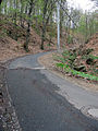
The historical connection path of the same name, officially named in 1893, runs in the valley between Wahnsdorf and the Grundmühle , a water mill on the Lößnitzbach . The one-lane street with a few alternative / stopping bays is declared a one-way street going downhill . The village ground is the only road connection between Wahnsdorf and the rest of Radebeul that is in Radebeul's area. The actual access roads to Wahnsdorf lead across the Moritzburg area.
The Wahnsdorfer Bach flows in the bottom, which flows into the Lößnitzbach and represents one of its left tributaries.
There are some abandoned quarries on the north side of the village .
Village ground uphill, on the right the Wahnsdorfer Bach

Wahnsdorfer Bach, in the village

Downhill village, on the right an abandoned quarry

View from Todhübel into the neck ditch, behind it it falls into the village ground

View from Todhübel of the Lößnitzgrund train station and the dairy shows the altitude that the village has to overcome


literature
- Frank Andert (Red.): Radebeul City Lexicon . Historical manual for the Loessnitz . Published by the Radebeul City Archives. 2nd, slightly changed edition. City archive, Radebeul 2006, ISBN 3-938460-05-9 .
Individual evidence
- ↑ Ordinance of the Landesdirektion Dresden to determine the area of community importance "Lößnitzgrund and Lößnitzhang" ( memento of the original from August 26, 2014 in the Internet Archive ) Info: The archive link was automatically inserted and not yet checked. Please check the original and archive link according to the instructions and then remove this notice. , accessed June 8, 2012.
- ↑ Overview map of the Habitats Ordinance with the drawing of the area and the village grounds , accessed on June 8, 2012.
Coordinates: 51 ° 7 ′ 15 " N , 13 ° 39 ′ 31.5" E