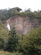
Todhübel
The Todhübel is a ground monument on a mountain spur on the eastern edge of the Lößnitzgrund in the Wahnsdorf district of the Saxon city of Radebeul , not far from the mountain inn "Zum Pfeiffer" .

At Quietzsch / Jacob, the system was run as a weir system "Death Hill" . In addition to the description "Tower hill castle in spur location with fore terrain and section ditch", it was stated that the protection took place on April 22, 1941 and was renewed on May 20, 1960.
description
South of the village ground, which leads from the Lößnitzgrund to the plateau to Wahnsdorf , rises up to 222.5 m above sea level. NHN the steeply sloping Todhübel to the Lößnitzgrund (there below 150 m above sea level ), on which there was a fortified manor complex (manor house) in the form of a tower hill castle from the 13th century.
The location corresponded to the complex of a spur castle with open access from the southeast. Coming from Wahnsdorf, the Todhübel is separated by a first ditch with a wall, behind which, according to the findings of archaeological research, there was a farm ( outer bailey ). Closer to the Lößnitzgrund there is a steeper, deeper neck ditch , which separates a smaller plateau ( Bühl ) about 15 m in diameter, which was probably protected by a palisade . A half- timbered residential defense tower, of which there are no more building remains , presumably stood on this .
On the rampart of the outer bailey “can be assumed [for reasons of protection]” a stone curtain wall which, “if it were found one day, would be the oldest stone structure in today's urban area” would “be built” at the same time as the “oldest [...] Masonry stuck in the tower foundation of the Friedenskirche ”.
To the north, west-north-west and south of the Todhübels are three former quarries from later times. Some of the annual events of the Karl May Festival take place in the quarry "Hoher Stein" to the south .
A historical assignment of this system is currently not possible.
geology
The medium-grain syenite consists mainly of potassium feldspar ( orthoclase and microline ), plagioclase and hornblende . The hornblende and feldspar crystals are arranged as a parallel structure. There are also dark, fine-grained excretions of irregular size, which consist of hornblende and biotite .
Plant communities
The forest there was described in terms of values from our homeland as consisting mainly of beeches , sessile oaks , English oaks and mountain ash trees . In bushy areas there are upright clematis , ostrich-flowered exuberant flowers , sparse alant , real Solomon's seal and common vertebrate . Sub - Mediterranean species, alpine vermicelli and continental sand - steppe species such as yellow scabiosa , mountain leek and timothy grass grow on open, semi -arid grasslands .
Protected area
The Todhübel is located in the area of the 115 hectare fauna-flora-habitat area Lößnitzgrund and Lößnitz slopes ( Natura 2000 area, EU registration number: DE4847304, state internal number: 159), to sub-area 2 ("Lößnitzgrund-Ost") . This sub-area 2 is "almost completely" in the Lößnitz landscape protection area .
literature
- Frank Andert (Red.): Radebeul City Lexicon . Historical manual for the Loessnitz . Published by the Radebeul City Archives. 2nd, slightly changed edition. City archive, Radebeul 2006, ISBN 3-938460-05-9 .
- Stefan Koch, Michael Strobel, Thomas Gerlach (together): Radebeul archaeological . In: Association for Monument Preservation and New Building Radebeul (ed.): Contributions to the urban culture of the city of Radebeul . Radebeul 2009.
- Harald Quietzsch , Heinz Jacob : The protected ground monuments in the Dresden district (= small writings of the State Museum for Prehistory Dresden. Volume 2). State Museum for Prehistory, Dresden 1982, pp. 30, 55–56.
- Lössnitz and Moritzburg pond landscape (= values of our homeland . Volume 22). 1st edition. Akademie Verlag, Berlin 1973.
Web links
Individual evidence
- ↑ a b Stefan Koch, Michael Strobel, Thomas Gerlach (comp.): Radebeul archaeological . In: Association for Monument Preservation and New Building Radebeul (ed.): Contributions to the urban culture of the city of Radebeul . Radebeul 2009, p. 28 .
- ^ Information from the State Office for Archeology on the Open Monument Day 2008, motto Past Uncovered - Archeology and Building Research
- ↑ a b Lössnitz and Moritzburg pond landscape. Values of our homeland , Volume 22, 1973, p. 168.
- ↑ Ordinance of the Dresden Regional Directorate for the determination of the area of community importance "Lößnitzgrund and Lößnitzhang" , accessed on June 8, 2012.
- ↑ Overview map of the Habitats Ordinance showing the area , accessed on June 11, 2012.
Coordinates: 51 ° 7 ′ 9 ″ N , 13 ° 39 ′ 23.7 ″ E


