
Wallring (Recklinghausen)
| Wallring (Recklinghausen) | |
|---|---|
|
|
|
 |
|
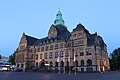
| View of the Herzogswall at night | |
| Basic data | |
| place | Recklinghausen |
| District | Old town / city center |
| Created | 1898 |
| Newly designed | 2009 |
| Places | Europaplatz Rathausplatz Lohtor |
| use | |
| User groups | Pedestrian traffic , bicycle traffic , car traffic , public transport , taxi traffic |
| Road design | Central islands lanes (partially) Tree alleys (partially) |
| Technical specifications | |
| Street length | 1.83 km |
The Wallring is a boulevard in Recklinghausen ( North Rhine-Westphalia ) that surrounds the city's historic old town almost in a circle and still follows the course of the former medieval town fortifications .
History of origin

A city walling of Recklinghausen has been proven for at least the first half of the 13th century; this was razed in 1296 and replaced around 1365 by a new, larger city wall, which was supplemented by a moat and a total of 16 wall towers.
At the beginning of the 19th century, the medieval walls lost their original meaning as industrialization began. The former fortifications became more and more an obstacle, slowing down and restricting trade. The Prussian provincial road from Bochum via Herne, Recklinghausen, Haltern and Dülmen to Münster ran through inner-city bottlenecks between the Viehor and the Lohtor.
The expansion into the later Wallring began with poplars, later maple trees and linden trees lining the carriage path around the walls in Recklinghausen. From 1850, work began to turn the avenues along the ring into a promenade . After ring road systems had already been built around the former city walls in Vienna (1858 to 1874), Dortmund (1860–1874) and Cologne (1881–1886), after several building alignment plans and tenders from 1885, the urban space beyond the old borders of the walls began open to the outside world. From 1901 the planned city expansion was in the hands of the master builder and town planner Hermann Josef Stübben , who had also been responsible for the expansion of Cologne and Dortmund.
In the first years of the 20th century, the town hall (inaugurated in 1908) and the district building (today: Willy-Brandt-Haus ; 1905) as well as in front of the city gates with the Paulus (1906) and Liebfrauenkirche (1903) were built directly on the wall. two of the largest Catholic and with the Christ Church (1911) the largest Protestant church in the city.
In 1910 the Wallring Recklinghausen was completed. What was special for the time was the fact that rain-proof paving was laid for carriages and automobiles over the entire length of the wall. In 2009 and 2010 the entire ring was extensively modernized, including a. with new lanes, new lighting and the planting of numerous trees, which should reflect the original alley character of the wall. Today, the Wallring is the main road with three to seven lanes and with around 30,000 vehicles a day, it is one of the busiest streets in the city.
Key data
The Recklinghäuser Wallring is, measured in the middle of the street, about 1830 meters long. This makes it only a little longer than the wall rings of the other two medieval towns in the district, namely the Wallring in Dorsten (Westvest; 1500 m) and that in Haltern (formerly the Hochstift Münster ; 1800 m), neither of which, however, are consistently developed as main roads . The Dortmund Wallring, also developed as a main road ring, is almost twice as long with 3400 m, the one in Münster even measures 4,400 m, but is primarily developed as a promenade and cycle path. The inner Cologne ring is as much as 5800 m long, although it is open to the east, to the Rhine, on a good 3 km bank stretch.
The eastern half of the Wallring lies between the Lohtor in the north and the Viehor in the south, almost flat at a constant between 68.5 m and 70.5 m above sea level. NHN . In contrast, the stone gate is significantly higher at 76.4 m , the highest point of the ring is between the old fire station and the confluence of the Westerholter Weg (es) a little higher. Here the vestibular ridge pushes itself from the east and north into the city center, where z. B. immediately in front of the grammar school church of the Petrinum (confluence with Große Geldstrasse / Steinstrasse ) 77.9 m . Correspondingly, the Königswall has an average gradient of at least 2.3% towards the Steintor; at Herzogswall, due to its greater length, it is only 0.9% mathematically, but the main slope is similarly high.
Naming
The wall is divided into five sections by the five former city gates. Counterclockwise, the names reflect the balance of power in which Recklinghausen found itself over the centuries: Grafenwall , Kurfürstenwall ( Electors of Cologne ), Herzogswall ( Duke of Arenberg ), Königswall ( Kings of Prussia ) and Kaiserwall ( German emperors from the house Hohenzollern ). This system is based on that of the Kölner Ring.

Kunibertitor
transition to Kunibertistraße
Cattle gate
transition to Breite Straße
Stone gate
seat of Radio Vest
Image of the historic stone gate with ramparts

Lohtor
view of Sankt Peter
Martinitor
crossing from the city center to the main station


Arterial roads, buildings and important institutions

Around the Wallring there are numerous representative buildings as well as monuments, sculptures and branches of well-known companies. The most important are listed below in clockwise order, starting in the east ("i" for inside, "a" for outside, "→" for arterial roads):
|
gallery
The following structures along the ring are arranged according to the above system (i.e. starting in the east):
town hall

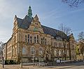
Villa Still in evening lighting

Bank branch on Königswall

City wall, Stephansturm and Castel Sant'Angelo
Willy Brandt House on Herzogswall

War memorial at the Lohtor


Individual evidence
- ↑ a b The development of the Recklinghausen Wallring and its naming Website of the city of Recklinghausen. Retrieved January 4, 2015.
- ^ Recklinghauser Zeitung: Problem child Wall. Renewed renovation necessary after only two years, article from May 15, 2012
- ↑ The value refers to the pure inner city framing without the castle / university.
- ↑ a b c d e f g h i j k l Topographical Information Management, Cologne District Government, Department GEObasis NRW ( information )
Coordinates: 51 ° 36 '52.8 " N , 7 ° 12' 6.5" E