Waltershausen (hall on the Saale)
|
Waltershausen
Market hall adSaale
Coordinates: 50 ° 19 ′ 0 ″ N , 10 ° 22 ′ 0 ″ E
|
||
|---|---|---|
| Height : | 278 m | |
| Area : | 6.01 km² | |
| Residents : | 475 (May 25 1987) | |
| Population density : | 79 inhabitants / km² | |
| Incorporation : | May 1, 1978 | |
| Postal code : | 97633 | |
| Area code : | 09762 | |
|
Location of Waltershausen in Bavaria |
||
Waltershausen is a district of the market hall on the Saale in the Lower Franconian district of Rhön-Grabfeld ( Bavaria ).
geography
Waltershausen is located in the Lower Franconian part of the grave field on the Spleen .
history
A Welf princess named Waltrat who was expelled from Bavaria is said to have settled in Hohenrod around 830, which was later named "Waltrathausen" after her. A knight dynasty "von Waltershausen", which died out in 1448, has been documented since the 13th century.
Later the Marschalk family came into possession of Ostheim ; they introduced the Reformation and rebuilt the church and castle.
With the Reichsdeputationshauptschluss of 1803, the mediatization of imperial direct classes began on a larger scale. The imperial-free rule in the Grabfeld was abolished by the Rhine Confederation Act of 1806 and incorporated into the Grand Duchy of Würzburg . With the dissolution of the Rhine Confederation in 1814 and the resolution of the Congress of Vienna , most of the Grand Duchy of Würzburg fell to the Kingdom of Bavaria . From 1817 Waltershausen belonged to the Lower Main District , which was renamed Lower Franconia and Aschaffenburg in 1838 (later just Lower Franconia).
The Waltershausen estate and castle, formerly owned by the von Kalb family , became the property of the Göttingen scholar and economic historian Georg Friedrich Sartorius at the beginning of the 19th century , who was raised to the hereditary Bavarian nobility due to his acquisition as Freiherr von Walterhausen. The estate with the castle essentially remained in the ownership of the Sartorius von Waltershausen family until the 20th century. In 1944 the castle was taken over by the Deutsche Reichspost as a rest home for postal workers.
On May 1, 1978, the previously independent community of Waltershausen was incorporated into the Markt Saal an der Saale.
In addition to the parish village , the former parish also included the three wastelands, the Buchmühle, the Papiermühle and the Weidachsmühle, former watermills on the Spleen. The community had an area of 600.85 hectares on the cut-off date of the census on June 25, 1961 .
On the cut-off date of the census on May 25, 1987, 475 inhabitants were counted in the area of the former municipality, in 142 buildings with living space and 161 apartments.
religion
The place is a Protestant parish village, which belongs to the Evangelical Lutheran Dean's Office Bad Neustadt an der Saale . The Protestant parish church was built in its present form in the late 16th century. Galleries surround the interior on three sides, and the organ is located above the altar. On the walls are 10 epitaphs of the Marschalk v. Ostheim (16th / 18th century) attached.
Culture and sights
Waltershausen Castle
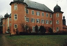
In 1619/27 a castle was built and in 1723 the Marschalk von Ostheim redesigned it into a three-winged castle with four helmeted round towers. The last of this family, Charlotte , married v. Kalb, went down in literary history as a witty friend of Schiller and Jean Paul. The young Friedrich Hölderlin stayed at Waltershausen Castle in 1793/95 as the tutor of her son. The lock later passed through several hands until it was set up as a rest home for the Federal Post Office. It has been privately owned by a Berlin family since 1986.
Inside there is a hall with a beautifully painted wooden ceiling from the time it was built; Another hall and several rooms on the second floor have a stucco decoration that is one of the finest creations of the Franconian Rococo.
Architectural monuments
See: List of architectural monuments in Waltershausen
Web links
- Waltershausen . In: Rhoen.info (Rhönlexikon)
- Waltershausen . In: Grabfeld-Grenzenlos.de
- Waltershausen Castle . In: Rhoen.info (Rhönlexikon)
- Waltershausen Castle . In: Grabfeld-Grenzenlos.de
- Norbert Dümpert: Private information website about Waltershausen ( Memento from January 6, 2014 in the Internet Archive )
Individual evidence
- ^ Federal Statistical Office (ed.): Historical municipality directory for the Federal Republic of Germany. Name, border and key number changes in municipalities, counties and administrative districts from May 27, 1970 to December 31, 1982 . W. Kohlhammer GmbH, Stuttgart and Mainz 1983, ISBN 3-17-003263-1 , p. 741 .
- ^ Official register of places for Bavaria, territorial status on October 1, 1964 with statistical information from d. 1961 population census, Munich, 1964 , column 886.
- ↑ Official directory for Bavaria, territorial status: May 25, 1987, Munich, 1991 , p. 375.
- ↑ Regina Vossenkaul: How Hölderlin mistakenly landed in the grave field. In: Mainpost.de. June 28, 2011, accessed July 30, 2018 .


