
Wanglspitze
| Wanglspitze | ||
|---|---|---|
 The Wanglspitze, with the mountain and valley station of the 150 Tux |
||
| height | 2420 m above sea level A. | |
| location | Tyrol , Austria | |
| Mountains | Tux Alps | |
| Coordinates | 47 ° 11 '4 " N , 11 ° 46' 31" E | |
|
||
| particularities | Mountain station 150er Tux on the summit | |

The Wanglspitze is a 2420 m above sea level. A. high mountain in the Tux Alps , part of the western slope of the Zillertal . The mountain is located in the northwestern part of the Penken ski area and is about seven kilometers west-northwest of Mayrhofen .
The 150 Tux was built on the eastern slope of the Wanglspitze in 2001 . The mountain station of this aerial tramway, which is only operated during the winter season, is on the summit of the Wanglspitze. During the summer months, the Wanglspitze can be reached via a hiking trail that takes just under two hours to walk from the summit area of the Penken via the Wanglalm to the mountain summit.
photos

The Wanglspitze, seen from the valley station of the 150er Tux.

A cabin of the 150 Tux at the mountain station at the summit of the Wanglspitze.
View from the Wanglspitze towards the valley station of the 150er Tux.

View from the Wanglspitze to the north, with the Pangert visible in the background.

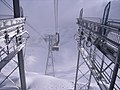
View from the Wanglspitze to the east, with the aerial tramway and a view of the Mayrhofen ski area .


literature
- Michael Reimer, Wolfgang Taschner: Hiking in the Zillertal. DuMont Buchverlag, Cologne 2001, ISBN 3-7701-5317-0 .
- Mayrhofen, Zillertal Alps, Gerlos, Krimml, Tuxertal, Zell im Zillertal. Hiking map 1: 50,000, sheet WK 152. Freytag & Berndt-Verlag Vienna, ISBN 978-3-85084-752-0 .