
Penken
| Penken | ||
|---|---|---|
 The Penken |
||
| height | 2095 m above sea level A. | |
| location | Tyrol , Austria | |
| Mountains | Tux Alps | |
| Dominance | 1.77 km → Wanglspitze | |
| Notch height | 71 m ↓ notch to Wanglalm | |
| Coordinates | 47 ° 10 '8 " N , 11 ° 47' 59" E | |
|
||

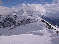
The Penken is a 2095 meter high mountain in the Tux Alps . It belongs to the western slope of the Zillertal and is about five kilometers west of Mayrhofen .
During the winter season, the Penken forms the core area of the Zillertal 3000 ski area and is accessed by several lifts, including the Finkenberger Almbahn , which leads from the bottom of the Tuxer Valley to the summit area of the mountain. In the summer months, the Penken is a hiking area with a large number of marked hiking trails. The starting point for many hiking routes is the mountain station of the Penkenbahn , which runs from the center of Mayrhofen to an altitude of around 1800 m above sea level. A. leads and operates all year round.
history
The use of the Penken as a winter sports area began in 1954 with the construction of the Penkenbahn . More cable cars followed later, so that the mountain slopes of the Penken (with the exception of the flat west side) have now been built over with numerous lifts.
The Garnet Chapel , designed by Mario Botta , has stood on the Penken since 2013 .
photos

The summit area of the Penken
The summit plateau of the Penken

Garnet Chapel by Mario Botta on the Penken in the Zillertal

Penken from the ascent to the Wangelspitze
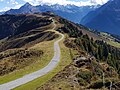
Penkenjoch

Penken children's playground


literature
- Walter Klier : Zillertal, with Gerlos and Tuxer Tal , Bergverlag Rother , Munich 2008. ISBN 978-3-7633-4175-7
- Michael Reimer, Wolfgang Taschner: Hiking in the Zillertal , DuMont Buchverlag, Cologne 2001. ISBN 3-7701-5317-0
- Freytag & Berndt-Verlag Vienna, hiking map 1: 50,000, sheet WK 151, Zillertal, Tux Alps, Jenbach-Schwaz . ISBN 978-3-85084-751-3
Web links
Individual evidence
- ↑ Garnet Chapel. Retrieved March 16, 2020 .