Tub (Tübingen)
|
Tub
District of Tübingen
Coordinates: 48 ° 32 '25 " N , 9 ° 2' 46" E
|
|
|---|---|
| Height : | 372 m above sea level NN |
| Residents : | 5204 (Dec. 31, 2007) |
| Postal code : | 72076 |
| Area code : | 07071 |
|
Tubingen tub
|
|
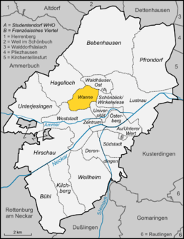
The tub is a district of the university town of Tübingen . It is located northwest of the city center .
Surname
The name of the district is based on the field name of the half-height. In parlance, the use of the article is common: the tub and on the tub . Consequently, the local elementary school also bears the name elementary school on the tub .
location
The eastern border to the districts of Waldhäuser Ost and Schönblick / Winkelwiese forms the Waldhäuser Straße . In the south and west, to the university district , the border runs from the Ochsenweide through the Käsenbachtal and east from the Morgenstelle to the Heuberger Tor . In the north, the district extends to Goldersbach before Bebenhausen and includes the hamlet of Waldhausen .
structure
These are mainly residential areas that emerged from the early 1960s (e.g. Horemer , Ochsenweide ). In the 80s the residential area on the Ursrainer Egert was added. The Kunsthalle Tübingen is located on Philosophenweg . To the east is the University Botanical Garden , which is already part of the University district. The old farm settlement of Waldhausen on the northern plateau was re-municipalityed from Bebenhausen to Tübingen in 1934 .

