Bühl (Tübingen)
|
Buhl
University city of Tübingen
|
|
|---|---|
| Coordinates: 48 ° 29 ′ 0 ″ N , 8 ° 59 ′ 49 ″ E | |
| Height : | 336 m above sea level NN |
| Area : | 6.41 km² |
| Residents : | 2194 (Jun 30, 2010) |
| Population density : | 342 inhabitants / km² |
| Incorporation : | July 1, 1971 |
| Postal code : | 72072 |
| Area code : | 07472 |
|
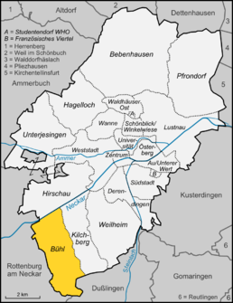
Location of Bühl in Tübingen
|
|
Bühl is a district of the university town of Tübingen in Baden-Württemberg ( Germany ).
geography
Bühl is located around six kilometers southwest of downtown Tübingen and around four kilometers east of Rottenburg am Neckar in the Neckar Valley .
expansion
The district area of the place is 641 hectares .
history
Bühl was first mentioned around 1100 as "de Buhile". Around 1120, the noble free von Bühl are called, in the 12th century the place came to the counts of Hohenberg . From 1292 Bühl was given as a fiefdom to Amman von Rottenburg, who held it until 1502. Then it was split up. Among others, the gentlemen von Ehingen zu Kilchberg and the gentlemen von Stein zum Rechtenstein were the owners. The latter ( David vom Stain ) built the Bühler Castle from 1550 . The sovereignty over Bühl was incumbent on Austria. The fief was withdrawn several times and pledged again.
In 1805 Bühl came to Württemberg and was assigned to the Oberamt Rottenburg . When it was dissolved in 1938, Bühl came to the Tübingen district . On July 1, 1971, Bühl was incorporated into the district town of Tübingen and thus lost its independence.
coat of arms
The blazon of the former municipal coat of arms reads: In blue, two diagonally crossed silver halberds . The coat of arms, which can be traced back to the old local nobility of Bühl, is no longer listed as an official coat of arms after the incorporation in 1971.
Culture and sights
In the middle of the well-preserved historical town center is the renaissance castle Bühl. The Bühler Tal nature reserve and the Hauser private farm museum are also worth seeing .
Buildings
- Renaissance Bühl Castle from 1522 in the historic town center
- Catholic village church St. Pankratius
- "Steinernes Brückle" over the Bühlertalbach
Individual evidence
- ^ Federal Statistical Office (ed.): Historical municipality directory for the Federal Republic of Germany. Name, border and key number changes in municipalities, counties and administrative districts from May 27, 1970 to December 31, 1982 . W. Kohlhammer, Stuttgart / Mainz 1983, ISBN 3-17-003263-1 , p. 534 .
- ^ Sights of Bühl , accessed on November 17, 2010
Web links
- Internet presence of the city of Tübingen on the Bühl district , accessed on November 17, 2010


