Weststadt (Tübingen)
|
West town
District of Tübingen
Coordinates: 48 ° 31 '19 " N , 9 ° 2' 26" E
|
|
|---|---|
| Height : | 346 m above sea level NN |
| Residents : | 8032 (Dec. 31, 2007) |
| Postal code : | 72070 |
| Area code : | 07071 |
|
Tübingen-Weststadt
|
|
The Weststadt is a district of the university city of Tübingen . It is located west of the city center and includes the western Ammertal as well as parts of the Schlossberg and the Neckar valley south of it.
location
The eastern border to the districts of university and city center runs from Steinenberg over Grafenhalde to Herrenberger Straße and west of the castle to the B 28 . In the south, the district borders on Derendingen with the Europastraße . In the west the border runs to Hirschau am Landgraben and eastern Spitzberg and to Unterjesingen to the west of the Ammerhof and the Himbach . In the north of the Weilersbach, the Hagelloch district is affected.
Attractions
- The oldest tree complex in Tübingen is located between the Wildermuth Gymnasium and the sports facilities of SV 03 Tübingen: Lindenallee .
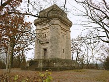
- As important building stands at the Lichtenberger way the Bismarck tower , which was built in 1907 and opened in 2000 after extensive renovation.
particularities
The southern part of Weststadt is made up of the fairground and exhibition grounds, the sports facilities of SV 03 Tübingen, the Paul Horn Arena multifunctional hall and the Tübingen outdoor pool .


