
Goldersbach
| Goldersbach | ||
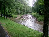
 Goldersbach near Tellerbrücke |
||
| Data | ||
| Water code | DE : 238168 | |
| location |
Schönbuch
|
|
| River system | Rhine | |
| Drain over | Ammer → Neckar → Rhine → North Sea | |
| origin | Confluence of the Großer Goldersbach and Kleiner Goldersbach rivers 48 ° 34 ′ 33 ″ N , 9 ° 2 ′ 7 ″ E |
|
| Source height | 389.3 m above sea level NHN | |
| muzzle | in Tübingen in the Ammer coordinates: 48 ° 31 ′ 37 ″ N , 9 ° 4 ′ 31 ″ E 48 ° 31 ′ 37 ″ N , 9 ° 4 ′ 31 ″ E |
|
| Mouth height | approx. 316 m above sea level NHN | |
| Height difference | approx. 73.3 m | |
| Bottom slope | approx. 8.9 ‰ | |
| length | 8.2 km | |
| Catchment area | 72.946 km² | |
| Right tributaries | → tributaries | |
| Flowing lakes | → tributaries | |
The Goldersbach is a brook in central Baden-Württemberg that flows into the Ammer from the left in the city of Tübingen . It runs almost entirely within the Schönbuch Nature Park . The catchment area covers an area of 73 km² and thus almost half of the nature park.
geography
course
The Goldersbach arises about 4 km upstream from Bebenhausen at the Teufelsbrücke through the confluence of the Großem Goldersbach (from the right) and the Kleinem Goldersbach (from the left).

It flows through the two Tübingen districts of Bebenhausen and Lustnau and flows into the Ammer at the sports facilities of the University of Tübingen at the foot of the Österberg .
Between Teufelsbrücke ( 389 m above sea level ) and the estuary (approx. 316 m above sea level ), the Goldersbach has a length of around 8.2 km and a gradient of around 73 meters in altitude. If you also add the Great Goldersbach , which at Neue Brücke about 5.6 km upstream from Teufelsbrücke to about 445 m above sea level. NN is brought to the way by its two source rivers Fischbach (right) and Lindach (left), the length of the Goldersbach is 14.1 km and it has a gradient of approx. 129 meters. If you also add the 5.7 km long Fischbach , which near the Herrenberger Waldfriedhof at about 543 m above sea level. NN rises, then the Goldersbach has a length of 19.8 km and a gradient of about 227 meters.
Inflow system
- Hierarchical: List of tributaries, also of higher order, from the origin to the mouth. Selection.
- Water lengths, areas and catchment areas according to the relevant data sets of LUBW-FG10, LUBW-SG10 and LUBW-GEZG.
- Heights as a rule according to the contour line image of the background map, where relevant also according to written height information on this.
- River names preferably based on the water body name on the background map, then the polygon labels on the background map, then the data set entries. Sometimes this results in different headwaters and source locations than according to the data records of the LUBW-FG10, this was then noted.
-
Goldersbach , from the left into the Ammer , 8.218 km and 72.946 km². Arises from the confluence of the left Kleine Goldersbach and the right Goldersbach at the Teufelsbrücke at 389.2 m above sea level. NN .
- Right source river Großer Goldersbach , confluence with left Kleine Goldersbach at the Teufelsbrücke at 389.2 m above sea level. NN , 5.902 km and 27.274 km². Arises from the confluence of the left Lindach and the right Fischbach at the Neue Brücke at around 445 m above sea level. NN .
- Left source river Lindach through the Mähdertal , confluence at the Neue Brücke at about 445 m above sea level. NN , 4.471 km and 10.67 km². Arises north of the Streitweg between Mönchgarten in the east and Kleiner Eiche in the west at about 527 m above sea level. NN . In the valley there is a long border between Herrenberg in the south / west and Hildrizhausen in the north / east.
- Another source branch of the Lindach , from the left in the Mönchkeller at about 488 m above sea level. NN , 1.046 km. Arises on the edge of the L 1184 at about 515 m above sea level. NN .
- Bach through the Lange Klinge , from the right at the eastern tip of the Brudergarten at about 476 m above sea level. NN , 1.66 km.
 Flows from a 0.2108 hectare pond in the Old Garden at 531 m above sea level. NN . Another 0.846 ha large pond, apparently with no outflow on the surface, is located about 150 m further uphill.
 - Stream through the Kreuzklinge , from the right to about 470 m above sea level. NN , 0.751 km. Arises next to the Kreuzweg at about 519 m above sea level. NN following him.
- Stream through the Kauppenklinge , from the left to about 467 m above sea level. NN , 1.588 km. Arises in the northwest of the Kirnberg near the Ludwig-Volz-Fir at about 520 m above sea level. NN . Runs through a 0.3737 hectare pond on the Lausterertanne.
- Bach through the Bläsisklinge , from the left to about 461 m above sea level. NN , 0.957 km. Arises in the southern Lindach at 507 m above sea level. NN .
- Lindach , from the left in the Mähdertal to about 459 m above sea level. NN , 1.8 km. Arises on a forest path
- Left source river Lindach through the Mähdertal , confluence at the Neue Brücke at about 445 m above sea level. NN , 4.471 km and 10.67 km². Arises north of the Streitweg between Mönchgarten in the east and Kleiner Eiche in the west at about 527 m above sea level. NN . In the valley there is a long border between Herrenberg in the south / west and Hildrizhausen in the north / east.
- Right source river Fischbach through the Kayhertal , confluence at the Neue Brücke at about 445 m above sea level. NN , 5.65 km and 7.741 km². Arises at the triangle in front of the eastern tip of the Herrenberger Waldfriedhof at about 543 m above sea level. NN .
-
Flows through the 1.0733 hectare brick pond
- Inflow from the Talwiesenhau , from the right immediately afterwards in the Talhägle at about 469.2 m above sea level. NN , 2.637 km. Arises between Moltscherr and Martinsgarten at about 545 m above sea level. NN .
-
- From the confluence of the Lindach and Fischbach rivers , the Große Goldersbach flows through the district of Ammerbuch , the municipal boundary to Altdorf in the north mostly runs in the valley at the left foot of the slope.
- Bach from the Weinbachtäle , from the right to about 436 m above sea level. NN , 1.782 km. Arises on Kayher Sträßle at about 523 m above sea level. NN .
- Stream through the brick blade , from the right at the thief bridge to about 431 m above sea level. NN , 1.513 km. Arises on the Kaiserlinde on Sommerstichweg at around 510 m above sea level. NN . In the floodplain there is a 0.3422 hectare lake in the upper triangle of the mouth.
- Right source river Großer Goldersbach , confluence with left Kleine Goldersbach at the Teufelsbrücke at 389.2 m above sea level. NN , 5.902 km and 27.274 km². Arises from the confluence of the left Lindach and the right Fischbach at the Neue Brücke at around 445 m above sea level. NN .
- Left source river Kleiner Goldersbach , confluence with the Große Goldersbach at the Teufelsbrücke at 389.2 m above sea level. NN , 3.631 km and 7.965 km². Arises on the edge of the southeastern tip of the Weiler Ebene less than 0.2 km west of the B 464 at about 500 m above sea level. NN (branch through Stoffel's cabbage blade ). On the longest part of the course, the border between Altdorf on the right and Tübingen on the left runs along the stream. With its longer right upper course Ochsenbach it reaches 5.731 km.
-
Ochsenbach , from the right to about 419 m above sea level. NN , 3.637 km. Arises a little north of the schnapps oak at about 506 m above sea level. NN .
- Western branch of the Ochsenbach , from the left to about 456 m above sea level. NN , 1.373 km. Arises in the western forest at about 515 m above sea level. NN .
-
Immediately after the estuary it runs through a 0.3117 hectare lake.
- Inflow along the Altdorfer Heusteige, from the right at a forest path bridge over the Ochsenbach to about 424 m above sea level. NN , 1.791 km. Arises just south of the Schnapseiche at about 521 m above sea level. NN .
-
Ochsenbach , from the right to about 419 m above sea level. NN , 3.637 km. Arises a little north of the schnapps oak at about 506 m above sea level. NN .
- The Goldersbach , created by the confluence, flows into the Tübingen district and remains there.
- Bach by the plate blade , right at the plate bridge at about 377 m above sea level. NN , 5.708 km and 8.862 km². Arises on the edge of the Tübingen Kohlplatte at about 465 m above sea level. NN .
- Exit of the Mühlkanal to Bebenhausen , to the left just before the following one.
-
Arenbach , from the right at the bridge on Bebenhäuser Straße at about 364 m above sea level. NN , 5.708 km and 8.862 km². Arises on the Paulineneiche at about 523 m above sea level. NN .
- Stream through the Pfaffenhau , from the right to about 466 m above sea level. NN , 0.901 km. Arises northeast of the Schönbuchspitze at about 508 m above sea level. NN .
-
Runs between two ponds directly in front of the Am Saurucken game reserve, 0.1144 ha and 0.0277 ha.
- Stream north along the Saurucken , from the right at the game reserve at about 433 m above sea level. NN , 0.905 km. Arises at the Entringer sports field above the Fohlensteige at about 467 m above sea level. NN .
- Brook through the Brockental , from the right to about 407 m above sea level. NN , 1.104 km. Arises from the Wellingtonia on Schweinhag at about 483 m above sea level. NN .
-
Happsteigbächle , from the left at the Becklesgartenhütte at 401.1 m above sea level. NN , 0 km and 2.287 km². Arises at the forest path cross at Kayher Sträßle on the Münsteiche at about 490 m above sea level. NN .
- Bach through the Bühlklinge , from the right to about 414 m above sea level. NN , 0.939 km. Arises next to the Kayher Sträßle at about 495 m above sea level. NN .
- Bach through the Garmerklinge , from the right to about 414 m above sea level. NN , 1.683 km. Arises between Kayher Sträßle and Platoeiche at about 480 m above sea level. NN .
- Bettelsbach , from the right to 359.9 m above sea level. NN , 1.983 km. Arises between Hölzlestor and Vogelbrunnen at about 480 m above sea level. NN .
- Goldersbach and the left Mühlkanal cross Bebenhausen side by side .
- Return of the Bebenhäuser Mühlkanal, from the left at the end of the village to about 348 m above sea level. NN , 1.839 km.
-
Seebach , from the left immediately after next to the L 1208 at about 347 m above sea level. NN , 5.35 km and 9.401 km². Arises between Altdorfer and Böblinger Sträßle at about 446 m above sea level. NN .
- Northern Seebach -Quellast, from the left under Baiernhau to about 424 m above sea level. NN , 1.002 km. Arises at the calf station next to the B 464 at about 474 m above sea level. NN .
- Bach through the Heckersklinge , from the left at the rest area next to the L 1208 under Baierhau at about 418 m above sea level. NN , 0.984 km. Arises on the northern edge of the game reserve at Schwedenkreuz at around 485 m above sea level. NN .
-
Brühlbächle , from the right to about 397 m above sea level. NN , 2.126 km. Arises on the Kohltorwiese at about 495 m above sea level. NN .
-
Passes two of the Brühlweiher at around 410 m above sea level. NN , 0.0971 ha and 0.0581 ha.
- Inflow along the Altdorfer Sträßles, from the left immediately afterwards to about 409 m above sea level. NN , 1.395 km. Arises west of the stone hut in the alders at about 462 m above sea level. NN .
-
Immediately before the mouth it flows through the two other Brühlweiher , 0.025 ha and 0.0903 ha.
-
-
- Inflow through the Kaltenbüchle , from the right opposite the König-Wilhelm-Stein at about 361 m above sea level. NN , 1.915 km. Arises on the southern edge of the meadow clearing in the foal pasture at about 493 m above sea level. NN .
-
Kirnbach , from the left at the Sunday point next to the L 1208 at 332.8 m above sea level. NN , 6.216 km and 9.174 km². Arises on Waldorfer Straße at about 491 m above sea level. NN .
- Source branch through the Bärlochklinge , from the left at the Mahneiche at 445.5 m above sea level. NN , 1.085 km. Arises south of the intersection of B 464 and K 6912 at about 501 m above sea level. NN .
- Eichenfirstbach , from the left north of a forest path bridge over the Kirnbach to about 427 m above sea level. NN , 1.594 km. Arises west of the castle oak in the Hänle at about 480 m above sea level. NN .
- Bach from the Bärlocheiche , from the right to about 422 m above sea level. NN , 1.097 km. Arises at the southeast corner of the game reserve at the Schwedenkreuz at around 475 m above sea level. NN .
- Bach through the Becklesklinge , from the left under the Manterswiese on the opposite slope to about 402 m above sea level. NN , 0.725 km. Arises near the K 6912 at about 485 m above sea level. NN .
- Stream through the Ziegelhäulesklinge , from the left to 382.3 m above sea level. NN , 0.626 km. Arises on the K 6912 near the newspaper oak at about 462 m above sea level. NN .
- Stream through the Triebklinge , from the left at a forest path bridge over the Kirnbach to about 368 m above sea level. NN , 0.847 km. Arises south of the Sophienpflege group of houses at about 456 m above sea level. NN .
- Immediately before the northern boundary of Lustnau in the Gewann Auchtert , a usually waterless retention basin was built in 2011 in the Goldersbachtal to the right of the stream and inaugurated in 2012. In the event of a flood, a 5.6 m high earth dam holds back up to 135,000 m³ of water that is discharged from the Goldersbach. The outflow is controlled.
- Kirchgraben , from the left in Tübingen at the beginning of Pfrondorfer Straße (K 6911) at around 225 m above sea level. NN , 1.604 km. Arises north of Lustnau just below the junction of the K 6912 from the K 6911 at about 423 m above sea level. NN .
Ecological importance
Since the Goldersbach is one of the few still unobstructed brooks in Baden-Württemberg , some rare species can be found in its valley, such as B. the shimmering kingfisher . Rare and endangered fish species such as the bullhead (Cottus gobio) , the brown trout (Salmo Trutta) or the river lamprey (Lampetra planeri) live in the stream . Stone cancer succumbed to cancer plague in the early 1990s.
In the past centuries, the Goldersbach caused severe floods in Tübingen-Lustnau several times . Its runoff behavior was intensively investigated by the Geological Institute of the University of Tübingen in the 1980s. At that time, the construction of a flood retention basin in the Goldersbachtal was up for discussion. Such a retention basin was inaugurated in March 2012.
gallery

Goldersbach origin

At Bebenhausen

Arenbach estuary

The Goldersbachtal can be cordoned off at short notice shortly before Lustnau and then serves as a retention basin
Muzzle into the Ammer


Individual evidence
- ↑ Text entry in black at the mouth on the background map of the geodata viewer, matching the contour line image.
- ↑ According to the contour line image on the background map of the geodata viewer.
- ↑ According to LUBW-FG10 (data record entries).
- ↑ Sum of the sub-catchment areas according to LUBW-GEZG (data record entries).
- ↑ Height indication in black at the mouth on the background map of the geodata viewer.
- ↑ Upper course according to the name on the background map of the LUBW-FG10 different from the polygon course there. LUBW-FG10 takes the following first - shorter and deeper - tributary as the upper course, which remains unnamed on the map itself and which has a catchment area that is almost as large as the Lindach upper course.
- ↑ LUBW-FG10 gives him only 1.211 km from a source on the left slope of the lower Alte Saufangklinge at about 492 m above sea level. NN .
- ↑ The LUBW-FG10 takes the longer Garmer blade source load as the upper course with a then greater total length of 2.125 km.
- ↑ The LUBW-FG10 takes the longer Bärlochklingen source load as the upper course with a greater total length of 6.553 km.
- ↑ Data on the dam system according to the relevant layer on: State Institute for the Environment Baden-Württemberg (LUBW) ( information )
Web links
Geoportal Baden-Württemberg ( information ), especially with the partial maps / layers
- the State Institute for the Environment, Measurements and Nature Conservation Baden-Württemberg (LUBW)
- "LUBW-FG10": River 1: 10,000
- "LUBW-GEZG": water catchment areas
- "LUBW-SG10": Standing water 1: 10,000