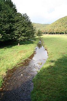
Wark (river)
|
Wark Waark |
||
|
The Wark |
||
| Data | ||
| location | Luxembourg | |
| River system | Rhine | |
| Drain over | Alzette → Sauer → Moselle → Rhine → North Sea | |
| source | Flur Kale Reis 49 ° 51 ′ 13 ″ N , 5 ° 55 ′ 11 ″ E |
|
| Source height | approx. 495 m | |
| muzzle | 50 meters south of Ettelbrück train station Coordinates: 49 ° 50 ′ 45 ″ N , 6 ° 6 ′ 24 ″ E 49 ° 50 ′ 45 ″ N , 6 ° 6 ′ 24 ″ E |
|
| Mouth height | 192.4 m | |
| Height difference | approx. 302.6 m | |
| Bottom slope | approx. 11 ‰ | |
| length | 28.4 km | |
| Discharge at the Ettelbrück A Eo gauge : 81.5 km² Location: 930 m above the mouth |
NNQ MNQ 2002–2012 MQ 2002–2012 Mq 2002–2012 MHQ 2002–2012 HHQ (03.01.2001) |
32 l / s 79 l / s 1.1 m³ / s 13.5 l / (s km²) 15.4 m³ / s 30.7 m³ / s |
The Wark ( Luxembourgish : Waark ) is a river in Luxembourg . It is a left tributary of the Alzette .
course
The Wark rises near Grevels in the municipality of Wahl and flows into the Alzette near Ettelbrück . The river is 28 km long and flows through Mertzig , Feulen and Welscheid .
Tributaries
- Fielserbaach ( left )
- Bruchbach ( left ), 1.9 km
- Turelbach ( left ), 9.0 km
- Mechelbach ( left ), 5.2 km
- Fel ( left ), 6.1 km
- Feischterbach ( left ), 1.6 km
- Maisbich ( left ), 1.4 km
- Brook ( left ), 1.8 miles
- Buurschterbaach ( left )
- Huesebaach ( left )
- Deifbaach ( right )
- Holzbaach ( right )
