Wasserberg (Aletshausen)
|
Water mountain
community Aletshausen
Coordinates: 48 ° 11 ′ 16 ″ N , 10 ° 24 ′ 1 ″ E
|
|
|---|---|
| Height : | 560–590 m above sea level NN |
| Residents : | 70 |
| Postal code : | 86480 |
| Area code : | 08282 |
|
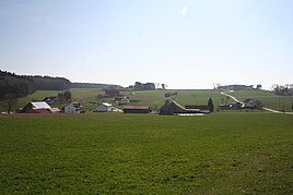
Wasserberg - View from the road between Aletshausen and Wasserberg
|
|
Wasserberg is a small village in the municipality of Aletshausen in the Swabian district of Günzburg .
location
The scattered settlement is located about one and a half kilometers southeast of Aletshausen in the Adelgerngraben valley .
history
Wasserberg was first mentioned in 1316 as a property of the Augsburg bishopric . Later, like Aletshausen , the place belonged to the Niederraunau lordship , which was long ruled by the Freyberg family. In the course of secularization at the beginning of the 19th century, like the entire Niederraunau rule, it became part of Bavaria . Since then it has belonged to the municipality of Aletshausen. Today the village has about 75 inhabitants.
Attractions
The chapel , which was built before 1834, is located at the highest point in the village, at house number 1 on the outskirts. The crucifix in the chapel from the 16th century and the other baroque furnishings point to a previous building, of which nothing is known.
See also
- List of architectural monuments in Aletshausen
- List of ground monuments in Aletshausen
- List of street names in Aletshausen
Web links
Individual evidence
- ↑ a b von Hagen, B. & Wegener-Hüssen, A. 2004: Monuments in Bavaria - Günzburg district - ensembles, architectural monuments, archaeological monuments. - Ed .: Bavarian State Office for Monument Preservation, Karl M. Lipp Verlag, Munich, ISBN 3-87490-589-6 , 600 pages (p. 15)
- ↑ a b page about the history of the villages belonging to the municipality of Aletshausen
- ↑ Ullmann, FG, (photos: Huber, M. & Huber, M.) 1992: Krumbach - Images from the city and the countryside in Central Swabia. - Müller Druck und Verlag, Krumbach, 157 pp.
