Moyopampa hydropower plant
| Moyopampa hydropower plant | |||
|---|---|---|---|
| location | |||
|
|
|||
| Coordinates | 11 ° 55 ′ 39 ″ S , 76 ° 41 ′ 22 ″ W | ||
| country |
|
||
| place | Lima region | ||
| Waters | Río Santa Eulalia , Río Rímac | ||
| Data | |||
| Type | Run-of-river power plant | ||
| power | 69.2 MW | ||
| operator | Enel | ||
| Start of operations | 1951 | ||
| turbine | 3 Pelton turbines | ||
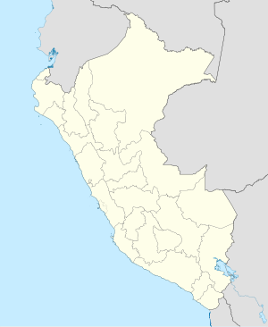
The hydroelectric power station Moyopampa (span. Central Hidroeléctrica Moyopampa ) is located on the edge of the Peruvian Western Cordillera , at the foot of the right slope of the lower river valley of the Río Rímac . It is located 41 km east-northeast of the state capital Lima in the district Lurigancho in Lima Province administrative region Lima . The plant is operated by Enel .
The Moyopampa hydropower plant is part of a power plant cascade. Upper current is the hydroelectric plant Callahuanca , the effluent water power plant Huampaní .
The first power plant unit of the Moyopampa hydropower plant was commissioned in 1951. The power plant is equipped with 3 horizontally directed Pelton turbines (with 21.3 MW, 22 MW and 24 MW). The total installed capacity is 69.2 MW. The gross height of fall is 468 m, the net height of fall is 460 m. The expansion water volume is 16.2 m³ / s. The average annual energy production is 468 GWh.
The water used by the power station comes from the Río Rímac and Río Santa Eulalia . There is a weir ( ⊙ ) directly below the Callahuanca hydropower plant , where the water is drained away . From there, the water is fed to the power plant via a 12.5 km long underground pipeline and three 800 m long pressure lines. Below the power plant, the water reaches the Río Rímac 150 m away.
![]() Map with all coordinates: OSM | WikiMap
Map with all coordinates: OSM | WikiMap
