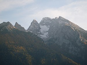
Red palfen
| Red palfen | ||
|---|---|---|
|
Red Palfen (back, far right) |
||
| height | 2367 m above sea level NHN | |
| location | Berchtesgadener Land , Bavaria | |
| Mountains | Berchtesgaden Alps , Northern Limestone Alps | |
| Dominance | 0.5 km → small age | |
| Coordinates | 47 ° 34 '41 " N , 12 ° 51' 44" E | |
|
|
||
The Rotpalfen or Wasserwandkopf is a 2367 m high peak in the Hochkalter massif in the German part of the Berchtesgaden Alps . It rises from the ridge that runs west of the blue ice from the Hochkalter to the north. In the north are the Hintersee and the town of Ramsau near Berchtesgaden .
The red palfen is seldom an independent destination for a mountain trip. Usually when climbing the Hochkalter it is crossed on the normal route from the Blaueishütte or bypassed to the west. The hut at an altitude of 1680 m can be reached from Hintersee via path 482. From there, a path leads over the moraine gravel of the Blaueis glacier to the southwest. The summit of the Rotpalfens is reached through a gravel channel in an easy climb to the west over the notch of the »beautiful spot« (places in difficulty level II on the UIAA scale).
A gorge runs between Rotpalfen and Kleinkalter, at the lower end of which the climbing route Alte Rotpalfen Südwand begins. The route is 450 meters long and has the difficulty V- and IV + . A climbing route of difficulty IV also leads through the east face. Another route leads as Rotpalfenriß over the southeast edge (V +).
Individual evidence
- ↑ Alte Rotpalfen south wall PDF, May 18, 2009
- ↑ Rotpalfen Ostwand on blauishütte.de PDF, May 18, 2009
- ↑ Rotpalfenriß on blauishütte.de PDF, May 18, 2009

