Weilerskopf
| Weilerskopf | ||
|---|---|---|
|
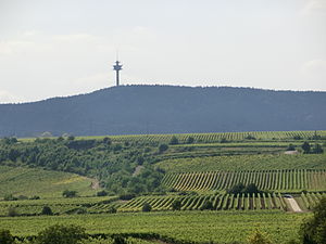
Weilerskopf from the east |
||
| height | 470.1 m above sea level NHN | |
| location | Palatinate Forest , Rhineland-Palatinate , Germany | |
| Mountains | Haardt | |
| Coordinates | 49 ° 29 '26 " N , 8 ° 7' 31" E | |
|
|
||
| particularities | Telecommunications tower Weilerskopf | |
The hamlet head is 470.1 m above sea level. NHN high mountain in a forest enclave of Herxheim am Berg northwest of Bad Dürkheim . The summit is the location of a telecommunications tower belonging to Deutsche Telekom AG .
Telecommunications tower
The Weilerskopf telecommunications tower is a type tower completed in 1969 .
Prayer rock
The prayer rock is a rock on the Weilerskopf. It is a 7 m long, 4 m wide and only 1.40 m high monolith made of sandstone . From this sandstone 12 steps were carved out (probably in Roman times). A Roman quarry is located near the prayer rock.

