Welzbach (Aubach)
| Welzbach | ||
|
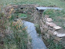
The Welzbach in meadows |
||
| Data | ||
| location |
Spessart
|
|
| River system | Rhine | |
| Drain over | Aubach → Lohr → Main → Rhine → North Sea | |
| source | in Wiesen am Friedhof 50 ° 6 ′ 36 ″ N , 9 ° 21 ′ 45 ″ E |
|
| Source height | 399 m above sea level NHN | |
| muzzle | in Wiesen at the fire station in the Aubach Coordinates: 50 ° 6 ′ 44 " N , 9 ° 21 ′ 56" E 50 ° 6 ′ 44 " N , 9 ° 21 ′ 56" E |
|
| Mouth height | 392 m above sea level NHN | |
| Height difference | 7 m | |
| Bottom slope | 20 ‰ | |
| length | 350 m | |
| Catchment area | 1.2 km² | |
The Welzbach is a right, periodic tributary of the Aubach in Wiesen in the Aschaffenburg district in the Bavarian Spessart .
geography
course
The Welzbach rises at an altitude of about 399 m above sea level. NHN a spring set in sandstones at the cemetery in the village of Wiesen . The spring dries up in summer and on dry days.
The stream initially runs in a north-easterly direction through a meadow, is then led into a pipeline on the edge of the village and finally flows into the fire station at an altitude of about 392 m above sea level. NHN on the right in the Aubach .

The Welzbach (pipe on the right) flows into the Aubach
|
Lohr river system
See also
Web links
Commons : Welzbach - collection of images, videos and audio files

