
Werle (prize)
Coordinates: 53 ° 16 ' N , 11 ° 41' E

Werle has been part of the municipality of Prislich in the Ludwigslust-Parchim district in Mecklenburg-Western Pomerania since 2004 .
Geography and traffic
Werle is located in the southwest of Mecklenburg-Western Pomerania, about 6.5 kilometers east of the official seat of Grabow , 1.5 kilometers south of Zierzow and two kilometers north of the state border with Brandenburg . The place is almost completely surrounded by agricultural land. In the east there is a mixed forest area called Bökhorst . The built-up area is slightly rising to the west at an altitude of 34–38 meters above sea level. The Meynbach runs two kilometers south of the village, the eastern part of which flows into the Tarnitz, which flows east of Werle .
District roads connect Werle with the surrounding towns such as Prislich, Zierzow and Balow . A connecting road leads to Klein Warnow in Brandenburg . A direct road connection to the former Hühnerland district of Werl was cut off around the year 2000 when the Berlin – Hamburg line was expanded , which no longer has any level crossings in Mecklenburg. Instead, there is now a bypass over the bridge at Neese . Rail and trunk road connections ( Bundesstraße 5 ) exist in Grabow.
history
Werle was first mentioned in a document in 1356. The place was laid out as a Sackplatzdorf and was once owned by knighthood. Today only the preserved park is evidence of the former manor house. As a former farmer's and estate village with collectivizations after the end of the Second World War, Werle was dominated by agriculture until 1990.
With effect from June 13, 2004 Werle was incorporated into Prislich.
Attractions
The church is a stone building from the 13th or first half of the 14th century. A half-timbered extension was added in 1719, but the interior was shortened to its original length in 1975. The von Ditten family crypt is located under the extension. In 1724 the interior was redesigned and the flat beamed ceiling was painted in Baroque style. The pulpit altar also dates from this time . A wooden crucifix hanging on the north wall was probably taken over from the previous church. In 1975 the former, lead-glazed patron's box was moved to the west wall and has since been used as a winter church. To the west of the church is a free-standing metal belfry. The church bell bears the coat of arms of the von Ditten family.

Field stone church in Werle

Inscription in a half-timbered extension
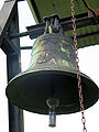
Church bell with family coat of arms


A residential building on Fritz-Reuter-Straße, the church with bell and cemetery wall and the former school are all under monument protection.
Web links
Individual evidence
- ↑ Description of the place Werle on amt-grabow.de
- ↑ Area changes 2004 (PDF; 62 kB) - State Statistical Office MV
- ↑ a b Zerniner Employment Initiative (ZEBI) e. V. and START e. V. (Ed.): Village and town churches in the Parchim parish . Edition Temmen, Bremen / Rostock 2001, ISBN 3-86108-795-2 , p. 112
- ↑ a b Georg Dehio : Handbook of German Art Monuments. Mecklenburg-Western Pomerania , Deutscher Kunstverlag, revision, Munich / Berlin 2000, ISBN 3-422-03081-6 , p. 674 f.
- ↑ List of monuments of the Altlandkreis Ludwigslust , as of May 2015 ( PDF file ( Memento of the original from November 26, 2015 in the Internet Archive ) Info: The archive link has been inserted automatically and has not yet been checked. Please check the original and archive link according to the instructions and then remove it Note. ).