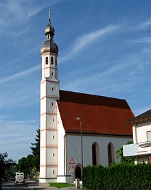
Western village St. Peter
Westerndorf St. Peter (official spelling Westerndorf St.Peter ) is one of 30 officially named parts of the municipality of the independent city of Rosenheim and also the name of a district.
The church village has 7929 inhabitants.
Federal highway 15 runs through the village . Significant traffic calming is expected from the commissioning of the Rosenheim west bypass , which is planned for 2022 .
The place north of Rosenheim used to be the capital of the independent municipality of the same name. The place and community were renamed from Westerndorf to Westerndorf St. Peter on September 26, 1951.
The community was largely incorporated into the city of Rosenheim on May 1, 1978. The northern part of Westerndorf St. Peter with Deutelhausen , Eichwald , Moos and Pfaffenhofen am Inn came to the municipality of Schechen , Filzen came to Großkarolinenfeld and Moorkultur came to Kolbermoor .
Westerndorf St. Peter has its own sports club and an adjacent primary and secondary school.
See also
- Westerndorf (Rosenheim) (Westerndorf am Wasen)
Web links
Individual evidence
- ^ Westerndorf St. Peter in the local database of the Bavarian State Library Online . Bavarian State Library
- ^ Richard Bauer: Handbook of the Bavarian offices, municipalities and courts 1799-1980, p. 561 ( online ).
- ↑ Bavarian State Office for Statistics and Data Processing (Hrsg.): The municipalities of Bavaria according to the territorial status May 25, 1987. The population of the municipalities of Bavaria and the changes in the acquisitions and territory from 1840 to 1987 (= contributions to Statistics Bavaria . Issue 451). Munich 1991, p. 22 , urn : nbn: de: bvb: 12-bsb00070717-7 ( digitized version ).
- ↑ Bavarian State Office for Statistics and Data Processing (Hrsg.): The municipalities of Bavaria according to the territorial status May 25, 1987. The population of the municipalities of Bavaria and the changes in the acquisitions and territory from 1840 to 1987 (= contributions to Statistics Bavaria . Issue 451). Munich 1991, p. 38 , urn : nbn: de: bvb: 12-bsb00070717-7 ( digitized version - Upper Bavaria, independent cities, footnote 3).
- ^ City archive Rosenheim: City history: incorporations and citizens' festival
- ↑ Bavarian State Office for Statistics and Data Processing (Hrsg.): The municipalities of Bavaria according to the territorial status May 25, 1987. The population of the municipalities of Bavaria and the changes in the acquisitions and territory from 1840 to 1987 (= contributions to Statistics Bavaria . Issue 451). Munich 1991, p. 53–54 , urn : nbn: de: bvb: 12-bsb00070717-7 ( digitized version - Rosenheim district, footnotes 16, 17 and 19).
- ↑ Ingrid Bloss-Mannal, Helga Heubach, Petra Hübner: Free State of Bavaria, the district of Upper Bavaria, Global Publishing, 1985, p 227 ( online ).
Coordinates: 47 ° 53 ' N , 12 ° 7' E

