Westminster, Colorado
| Westminster | |
|---|---|
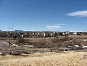
 Westminster with the Rocky Mountains in the background |
|
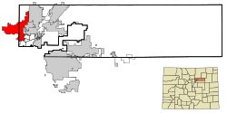
| Location in Colorado | |
| Basic data | |
| Foundation : | 1859 |
| State : | United States |
| State : | Colorado |
| Counties : |
Adams County Jefferson County |
| Coordinates : | 39 ° 52 ′ N , 105 ° 3 ′ W |
| Time zone : | Mountain ( UTC − 7 / −6 ) |
| Residents : | 106,114 (as of 2010) |
| Population density : | 1,300.4 inhabitants per km 2 |
| Area : | 85.1 km 2 (approx. 33 mi 2 ) of which 81.6 km 2 (approx. 32 mi 2 ) is land |
| Height : | 1641 m |
| Postcodes : | 80003, 80005, 80020, 80021, 80023, 80030-80031, 80035, 80036, 80221, 80234, 80241, 80260 |
| Area code : | +1 303, 720 |
| FIPS : | 08-83835 |
| GNIS ID : | 0204703 |
| Website : | www.ci.westminster.co.us |
| Mayor : | Nancy McNally |
Westminster is an American city in two counties, Adams County and Jefferson County (west of Sheridan Boulevard) in the US state of Colorado . With 106,114 inhabitants (as of 2010 ), it is one of the small towns in the United States, but is fully integrated into the Denver metro area, and it is the ninth largest city in Colorado. The geographic coordinates are 39.88 ° North and 105.05 ° West. They designate the region in the area of transition from the Great Plains to the Rocky Mountains . The area of the city in the northern metropolitan area of Denver is 85.1 km². The town's landmark is the town hall's bell tower, which also adorns the town's logo. The Westminster Promenade with cinema center (24 theaters), ice rinks, insect zoo, restaurants and shops is a special attraction of the residential area dominated by whites .
