Whale Island (New Zealand)
| Whale Island (New Zealand) | ||
|---|---|---|
| Whale Island as seen from the south | ||
| Waters | Bay of Plenty ( South Pacific ) | |
| Geographical location | 37 ° 51 '20 " S , 176 ° 58' 25" O | |
|
|
||
| surface | 1.43 km² | |
| Highest elevation | 354 m | |
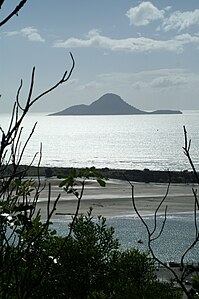
| Whale Island from the Kohi Point Walkway near Whakatane | ||
Whale Island ( Māori : Moutohora ) is a small island off the coast of the Bay of Plenty in the region of the same name on New Zealand's North Island .
geography
The island is about twelve kilometers north of the city of Whakatāne . It got its English name from a whaling station that was built here in the 19th century . The 1.43 km² island is a remnant of a volcano from the Pleistocene , of which only two peaks have remained due to erosion . The area is still volcanically active. There are hot springs in the Sulfur Valley, McEwans Bay and Sulfur Bay .
history
There are several archaeological sites of the Māori and European settlers on the island . These include an extensive Pā on Pa Hill and a number of residential terraces and gardens, køkkenmøddinger (deposits of leftover food), areas where stone tools were made and stone walls. Even after the island was no longer permanently inhabited by Māori after the early 19th century, members of the Iwi Ngāti Awa and Tuhoe visited the island in search of sea creatures and the dark shearwater as well as stones for their underground ovens ( hangi ).
The first European settlers attempted whaling from the coast in the 1830s. The operation failed without a single whale being caught. Forty years later, attempts were made to make money in sulfur , which was sold to a refinery in Auckland for a few years but was of poor quality. In 1895, sulfur mining was also given up. From 1915 to 1920, 26,000 tons of stones were mined on the island for the construction of the Whakatane harbor wall.
ecology
In 1965 Moutohora was declared a nature reserve and acquired by the Krone in 1984. After wild goats were exterminated on the island, 12,000 plants from 45 species were planted . The island is now covered with a mosaic of Pōhutukawa , Māhoe , Kanuka , bracken and grasslands.
190 native and 110 introduced plant species grow on the island. Today it is free from domestic goats, rats, cats and rabbits, which had previously decimated the local flora and fauna. The most important fauna component of the island is a breeding colony of the long-winged petrel ( Pterodroma macroptera ).
Dark shearwater , little penguin , Maori plover and various oystercatchers also breed on the island. Endangered species that occasionally visit the island include the predatory tern , North Island kākā, and the maori falcon . There are also other forest birds, wild goat parakeets , three types of lizards and the New Zealand fur seal .
In March 1999, in cooperation with the local Iwi Ngāti Awa and the Department of Conservation, two saddle birds ( Philesturnus carunculatus ) were relocated from Cuvier Island off the Coromandel Peninsula to Moutohora. After a short time, however, they returned to Cuvier Island.
Access to the island is only permitted with the approval of the Department of Conservation in Whakatane and as part of organized tours and school trips.
swell
- Whale Iceland in the Global Volcanism Program of the Smithsonian Institution (English)


