Whangaroa (New Zealand)
| Whangaroa | ||
| Geographical location | ||
|
|
||
| Coordinates | 35 ° 3 ′ S , 173 ° 45 ′ E | |
| Region ISO | NZ-NTL | |
| Country |
|
|
| region | Northland | |
| District | Far North District | |
| Ward | Bay of Islands - Whangaroa Ward | |
| Residents | few | |
| height | 8 m | |
| Post Code | 0478 | |
| Telephone code | +64 (0) 9 | |
| Photography of the place | ||
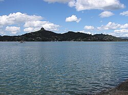
 View of St. Paul's Rock on the Whangaroa Harbor |
||
Whangaroa is a settlement in the Far North District of Northland on the North Island of New Zealand .
Origin of name
The name of the settlement means “long port” in the Māori language .
geography
The settlement is located around 27 km northwest of Kerikeri on the southeast bank of Whangaroa Harbor . The closest settlement is Kaeo , around 6.5 km southeast. After around 5.5 kilometers of road in the same direction, the settlement is connected to the New Zealand State Highway 10 .
history
The region was already inhabited by Māori before the Europeans arrived . In October 1809, Whangaroa Harbor was the site of the Boyd massacre , in which almost the entire crew and 70 passengers of the Boyd were killed by Māori . Remains of the ship are in a local museum. In June 1823 the Wesleyans built their first New Zealand mission station on the banks of the natural harbor. However, it was destroyed by fire in 1827.
In March 1828, Hongi Hika , the famous chief of the Ngāpuhi , died in Whangaroa .
From the middle of the 19th to the beginning of the 20th century, the heyday of shipbuilding was in the settlement where over 100 ships were built in Whangaroa . The wood for this came from the surrounding Kauri forests, the areas of which were converted into pastureland after the deforestation.
tourism
Whangaroa has a marina and is used as a starting point for deep sea fishing . Water sports, boat trips, snorkeling and an 18-hole golf course are available for recreational activities.
Attractions
The " St. Paul " volcanic vent near Whangaroa is under protection, as is the " St Paul's Rock Scenic Reserve " and offers a good view of the natural harbor and its surroundings.
literature
- Helga Neubauer: Whangaroa . In: The New Zealand Book . 1st edition. NZ Visitor Publications , Nelson 2003, ISBN 1-877339-00-8 , pp. 154 .


