Wharanui
| Wharanui | ||
| Geographical location | ||
|
|
||
| Coordinates | 41 ° 56 ′ S , 174 ° 5 ′ E | |
| Region ISO | NZ-MBH | |
| Country |
|
|
| region | Marlborough | |
| District | Marlborough District | |
| Ward | Wairau-Awatere Ward | |
| Residents | few | |
| height | 5 m | |
| Post Code | 7285 | |
| Telephone code | +64 (0) 3 | |
| Photography of the place | ||
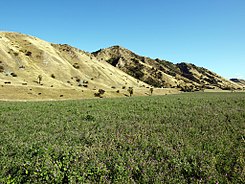
 Wharanui Farmland |
||
Wharanui is a small settlement in the Marlborough District on the South Island of New Zealand .
geography
The settlement is located on a 20 km long and up to 2 km wide coastal strip between Ward and Clarence , on the northern part of the east coast of the South Island. The Wharanui coastline stretches from Chancet Rocks in the north to Willawa Point in the south. It essentially consists of sand dunes and fertile alluvial land.
Blenheim in the north is 61 km away by road and Kaikoura in the southwest is around 70 km. With excellent transport connections, the New Zealand State Highway 1 runs along the coast directly through the farmland of the settlement. The South Island Main Trunk Railway also crosses the settlement area, but today no longer has any stopping point for traffic connections.
Geological anomaly
A scientific article published in 1988 discussed where the exceptionally high levels of iridium and 18 different other elements found in the Wharanui area might come from. In particular, the high concentrations of nickel , chromium and iridium, the concentration of which is atypical for layers of the earth's crust , could indicate that a meteorite impact occurred in the area at the end of the Cretaceous period .
history
Wharanui is the Maori name of an indigenous species of flax, phormium tenax , and flax was exactly what the early settlers in the area grew .
When the South Island Main Trunk Railway was built from Blenheim further south on the east coast, the town got its own small train station in 1915. The station was opened on October 3, 1915 for goods transport and on December 4, 1915 for passenger transport. On March 29, 1981 the passenger transport was stopped and on October 13, 1986 the connection to the freight transport would give up.
Sightseeing
The most impressive building in the area is the small Anglican Church of St Oswalds , which is located directly on the State Highway and anyone passing by will notice it immediately. The church was built in 1927 by the settler Charles Frank Murray . The Murray family owned the largest property in the settlement area at the time. Today the church is used by the Awatere Christian Joint Venture , which is made up of all Christian faiths.
literature
- Helga Neubauer: Wharanui . In: The New Zealand Book . 1st edition. NZ Visitor Publications , Nelson 2003, ISBN 1-877339-00-8 , pp. 635 .
Individual evidence
- ↑ Shona McCahon and other authors: South Marlborough Coastal Marine & Terrestrial Areas . In: Marlborough District Council (Ed.): Marlborough Coastal Study . Wellington June 2014, p. 250 (English, online [PDF; 3.3 MB ; accessed on December 10, 2014]).
- ↑ Topo250 maps . Land Information New Zealand , accessed September 6, 2017 .
- ^ CP Strong, RR Brooks, CJ Orth, Xue-Ying Mao : An iridium-rich calcareous claystone (Cretaceous-Tertiary boundary) from Wharanui, Marlborough, New Zealand . In: Royal Society of New Zealand (Ed.): New Zealand Journal of Geology and Geophysics . Volume 31, 1988, ISSN 0028-8306 , pp. 191–195 , doi : 10.1080 / 00288306.1988.10417768 (English).
- ^ Juliet Scoble : Names & Opening & Closing Dates of Railway Stations in New Zealand - 1863 to 2010 . (PDF; 909 kB) Rail Heritage Trust of New Zealand , accessed on December 10, 2014 (English, page 142).
- ^ Awatere and East Coast Churches . Anglican Diocese of Nelson , accessed December 10, 2014 .

