Wildcat Creek (Wabash River)
| Wildcat Creek | ||
|
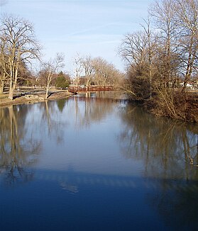
The course of the Wildcat Creek at the top right of the picture |
||
| Data | ||
| Water code | US : 446017 | |
| location | Indiana (USA) | |
| River system | Mississippi River | |
| Drain over | Wabash → Ohio → Mississippi → Gulf of Mexico | |
| source | in Howard County 40 ° 26 ′ 2 ″ N , 85 ° 53 ′ 29 ″ W. |
|
| muzzle |
Wabash River Coordinates: 40 ° 28 ′ 18 " N , 86 ° 51 ′ 30" W 40 ° 28 ′ 18 " N , 86 ° 51 ′ 30" W. |
|
| Mouth height |
204 m
|
|
| length | approx. 135 km | |
| Catchment area | 2083 km² (excluding South Fork Wildcat Creek: 1118 km²) | |
| Discharge at the Lafayette A Eo gauge : 2055 km² Location: 8 km above the estuary |
MQ 1955/2016 Mq 1955/2016 |
23 m³ / s 11.2 l / (s km²) |
| Reservoirs flowed through | Kokomo Waterworks Reservoir No. 2 | |
| Medium-sized cities | Kokomo , Lafayette | |
| Communities | Burlington , Greentown | |
|
Wildcat Creek at Foster Park in Kokomo |
||
| South Fork Wildcat Creek | ||
| Water code | US : 443814 | |
| source | in Clinton County 40 ° 18 ′ 42 " N , 86 ° 18 ′ 52" W. |
|
| muzzle | Wildcat Creek 40 ° 26 ′ 15 ″ N , 86 ° 48 ′ 6 ″ W. |
|
| Mouth height |
167 m
|
|
| Catchment area | approx. 960 km² (without Middle Fork Wildcat Creek: approx. 647 km²) | |
| Communities | Michigantown , Mulberry | |
| Middle Fork Wildcat Creek | ||
| Water code | US : 439105 | |
| source | in Clinton County 40 ° 23 ′ 16 " N , 86 ° 21 ′ 14" W. |
|
| muzzle | South Fork Wildcat Creek 40 ° 25 ′ 25 ″ N , 86 ° 46 ′ 15 ″ W. |
|
| Mouth height |
173 m
|
|
| Catchment area | 313 km² | |
The Wildcat Creek is a left tributary of the Wabash River in the US state of Indiana . The river is about 135 km long. Its catchment area covers 2083 km². The mean discharge not far from the mouth is 23 m³ / s.
Wildcat Creek arises 8 km southeast of Greentown in southeast Howard County at the confluence of two source streams. It flows mainly in a westerly direction. It passes Greentown and shortly thereafter becomes Kokomo Waterworks Reservoir No. 2 pent up. Below the dam, Wildcat Creek flows through the town of Kokomo . The river meanders further west and passes the village of Burlington . Eventually he reaches the eastern outskirts of Lafayette , where the South Fork Wildcat Creek meets him when coming from the south. Wildcat Creek turns north and flows into the Wabash River after another 13 kilometers. Below Kokomo, the river shows a strongly meandering behavior.
The South Fork Wildcat Creek has its source in Clinton County . It flows mainly in a westerly direction. He passes Michigantown . The city of Frankfort is 3 km south of the river. The river passes Mulberry and then turns north. The Middle Fork Wildcat Creek meets the river 7 km above the mouth from the east. The South Fork Wildcat shows a strongly meandering behavior below Mulberry.
The Middle Fork Wildcat Creek also rises in Clinton County. It flows in a westerly direction. It runs between Wildcat Creek in the north and South Fork Wildcat Creek in the south. At its lower reaches, the river runs north of Rossville .
Web links
- Wildcat Creek (North & South Forks) at Indiana Dept. of Natural Resources
- Map of the 3 rivers near Indiana Dept. of Natural Resources
Individual evidence
- ↑ Wildcat Creek in the United States Geological Survey's Geographic Names Information System
- ↑ a b Wildcat Watershed - 12 Digit HUCs (PDF 760 KB) USDA - NRCS. Retrieved August 3, 2017.
- ↑ USGS 03335000 WILDCAT CREEK NEAR LAFAYETTE, IN
- ↑ South Fork Wildcat Creek in the Geographic Names Information System of the United States Geological Survey
- ↑ IDEM OWQ Watersheds: Wildcat Creek, South
- ↑ Middle Fork Wildcat Creek in the Geographic Names Information System of the United States Geological Survey
- ↑ IDEM OWQ Watersheds: Wildcat Creek, Middle

