Wilhelmina Bay
| Wilhelmina Bay | ||
|---|---|---|
|
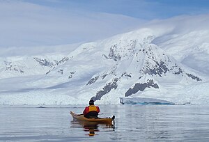
Whale watching from a kayak in Wilhelmina Bay |
||
| Waters | Gerlache Street | |
| Land mass | Grahamland , Antarctic Peninsula | |
| Geographical location | 64 ° 39 ′ S , 62 ° 10 ′ W | |
|
|
||
| width | (roughly estimated) 25 km | |
| Islands | Bearing Island , Brooklyn Island , Delaite Island , Emma Island , Enterprise Island , Fleurus Island , Louise Island, Nansen Island , Pelseneer Island , Pythia Island , Racoviță Islands , Wyck Island | |
| Tributaries | Blanchard Glacier , Leonardo Glacier | |
The Wilhelmina Bay ( French Baie Wilhelmine ) is a bay on the Danco Coast of Graham Lands on the Antarctic Peninsula . It lies between the Reclus Peninsula and Cape Anna .
It was discovered during the Belgica expedition (1897–1899) led by the Belgian polar explorer Adrien de Gerlache de Gomery . It is named after the then Dutch monarch Wilhelmina (1880–1962).
Web links
- Wilhelmina Bay in the Geographic Names Information System of the United States Geological Survey (English)
- Wilhelmina Bay on geographic.org (English)

