Willkawain (place)
| Willkawain | ||
|---|---|---|
|
|
||
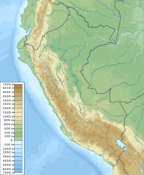
| Coordinates | 9 ° 29 ′ S , 77 ° 31 ′ W | |
| Basic data | ||
| Country | Peru | |
| Ancash | ||
| province | Huaraz | |
| ISO 3166-2 | PE-ANC | |
| District | Independencia | |
| height | 3350 m | |
| Residents | 2124 (2017) | |
|
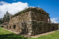
Willkawayin Temple
|
||
Willkawain , alternative spelling: Wilcahuain , is a town in the Independencia district in the Huaraz province in the Ancash region in western Peru . Together with the neighboring village of Paria, Willkawain has 2124 inhabitants (as of 2017).
location
Willkawain is about 6 km northeast of Huaraz at the foot of the Cordillera Blanca further east at an altitude of 3350 m .
Transport links
- A road leads from Huaraz through the village to the high mountains.
- A footpath leads down to Monterrey (approx. 4 km).
Attractions
On the outskirts above the cemetery is the Willkawayin temple .
literature
- Rolf Seeler: Peru and Bolivia. DuMont Buchverlag, Cologne 2001, ISBN 3-7701-4786-3 .
- Alan Murphy: Peru Handbook. 2nd edition. Footprint Handbooks, Bath 1999, ISBN 0-8442-2187-2 , p. 312 (English).
- Gerhart Moser: Cordillera Blanca. South. = Cordillera Blanca, South, Perú. Trekking map. Austrian Alpine Club, Innsbruck 2005, ISBN 3-937530-05-3 ( Alpine Club Map 0.3b), (scale 1: 100,000; legend in German, Spanish, English).
Individual evidence
- ↑ Peru: Ancash - Provinces & Places . www.citypopulation.de. Retrieved June 6, 2020.
Web links
Commons : Willkawain - collection of images, videos and audio files

