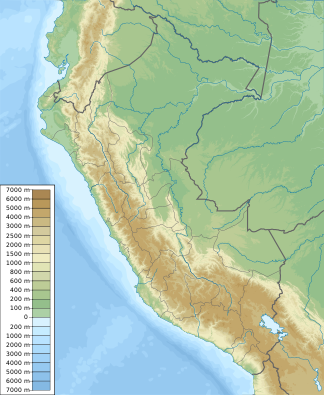
Cordillera Blanca
| Cordillera Blanca | ||
|---|---|---|
| Highest peak | Huascarán ( 6768 m ) | |
| location | Peru | |
|
|
||
| Coordinates | 9 ° 7 ′ S , 77 ° 36 ′ W | |
The Cordillera Blanca in the northern Andes of Peru , with a length of 180 km and more than 50 mountains over 5700, the highest mountain range in meters of the American continent and also the highest in the tropics. Only in Asia are there on average higher mountain ranges. Translated, the name means White Cordillera , which indicates the strong glaciation . Another name is Cordillera Tropical . Between this mountain range and the Pacific lies the Cordillera Negra , which is completely free of snow.
The highest mountain of the Cordillera Blanca (as well as Peru) is the Huascarán (6768 m). The Alpamayo (5947 m) further north is generally considered to be one of the most beautiful mountains in America and the world . Other important mountains are Ranrapalca , Huantsán , Taulliraju , Huandoy , Cerro Pisco , Chopicalqui , Artesonraju and Nevado de Copa . Most of these mountains were first climbed during the German-Austrian Alpine Club expeditions in the 1930s. The first maps of the mountains were also created in the course of this.
The Cordillera Blanca is a weather divide that separates the humid rainforest region ( Selva ) from the arid Pacific coastline . It represents a pronounced barrier for the dominant eastern air currents, which bring humid air masses from the Amazon basin . About 90% of the annual precipitation falls from October to April. The mountain range is also the watershed between the Río Marañón and the Atlantic in the east and the Río Santa and the Pacific in the west. Temperatures hardly fluctuate over the course of the year, but they have a pronounced daily cycle .
In the Cordillera Blance there are the most extensive glacier areas in tropical latitudes, about a quarter of all tropical glaciers are located there. According to estimates, the area covered by glaciers in 1930 was more than 800 km². According to various analyzes of satellite data, in 2003 it was just under 570 km² distributed over 485, mostly small, glaciers, and in August 2010 it was 482 km² (→ glacier retreat since 1850 ). The glacier retreat can largely be explained by rising temperatures and changing precipitation patterns (→ global warming ). The tropical climatic conditions mean that the ablation period of lower-lying glacier areas covers the whole year. Because of this, and because of their small area and thickness, their great slope and their relatively low altitude in the feeding areas, the glaciers of the Cordillera Blanca react quickly to climate changes.
In the dry season, meltwater from the glaciers and groundwater flowing from the Cordillera Blanca supply the Río Santa and make a significant contribution to the water supply for the population, agriculture, hydropower plants and mining. The retreat of the glaciers is expected to have severe social and environmental consequences along the Río Santa.
The main town on the southwestern edge of the Cordillera Blanca is Huaraz , other important cities are Caraz and Yungay .
A large part of the Cordillera Blanca was declared a Huascarán National Park in 1975 and a UNESCO World Heritage Site in 1985 because of its particular scenic beauty and geological features and is completely under protection. The park is one of the most popular tourist spots in Peru and can be visited for a fee.
Well-known peaks
- Nevado Huascarán ( 6768 m )
- Huandoy ( 6395 m )
- Huantsán ( 6395 m )
- Palcaraju ( 6274 m )
- Ranrapalca ( 6162 m )
- Nevado Chacraraju ( 6112 m )
- Tocllaraju ( 6034 m )
- Alpamayo ( 5947 m )
- Nevado de Tuco ( 5454 m )
Web links
Individual evidence
- ↑ a b c A. Juricova and S. Fratianni: Climate change and its relation to the fluctuation in glacier mass balance in the Cordillera Blanca, Peru: a review . In: AUC Geographica . tape 53 , no. 1 , June 2018, doi : 10.14712 / 23361980.2018.10 .
- ↑ Patrick Burns and Anne Nolin: Using atmospherically-corrected Landsat imagery to measure glacier area change in the Cordillera Blanca, Peru from 1987 to 2010 . In: Remote Sensing of Environment . tape 140 , January 2014, doi : 10.1016 / j.rse.2013.08.026 .
- ↑ Robin Glas u. a .: A review of the current state of knowledge of proglacial hydrogeology in the Cordillera Blanca, Peru . In: Wiley Interdisciplinary Reviews: Water . June 2018, doi : 10.1002 / wat2.1299 .
- ↑ World Heritage List - Huascarán National Park - Description. UNESCO World Heritage Convention, accessed August 25, 2018 .

