
Tocllaraju
| Nevado Tocllaraju | ||
|---|---|---|
 Tocllaraju from the southwest (2010) |
||
| height | 6034 m | |
| location | Ancash , Peru | |
| Mountains | Cordillera Blanca , Andes | |
| Dominance | 3 km → Palcaraju Oeste | |
| Notch height | 482 m ↓ nameless notch | |
| Coordinates | 9 ° 21 '12 " S , 77 ° 23' 59" W | |
|
||
| Type | Ice peaks | |
| rock | Batholith | |
| First ascent | Walther Brecht and Hans Schweizer on July 31, 1939 | |
| Normal way | Alpine tour over the northwest ridge ( D ) | |

The Nevado Tocllaraju ( Tuqllarahu in Ancash-Quechua ) is a 6034 m high mountain in the Peruvian Cordillera Blanca . Despite heavy glaciation, it is one of the most climbed mountains in the tropical mountain range.
Surname
The name Tuqllarahu comes from the Quechua dialect ( Ancash-Quechua ) that is widespread in the Ancash region and is composed of the words tuqlla (trap) and raju or rasu (snow). The Spanish name is recorded on the map of the Alpine Club with the attribute Nevado (snowy, snow-covered), which stands for glaciated mountain peaks throughout the Andes (cf. for example Nevado Huascarán ).
Location and surroundings
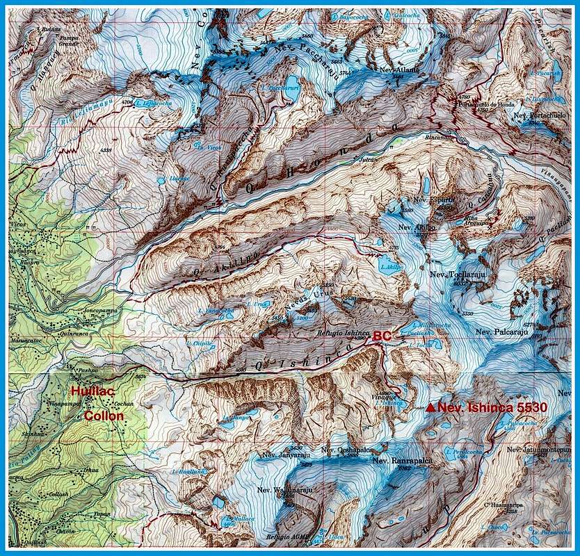
The Tocllaraju is located in the Huascarán National Park in the southern part of the Cordillera Blanca around 25 km northeast of Huaraz . The heavily glaciated summit is connected by a ridge to the 240 m higher Palcaraju , which forms the provincial border between Carhuaz and Huaraz . There are numerous gorges all around, including the Quebrada Ishinca to the southwest and the mining Quebrada Cancahua to the north of the mountain. The east side of the six-thousander is shaped by glacier tongues , while slope glaciers dominate on the west side . There are some smaller glacial lakes like Lake Akilpo west of Tocllaraju. The closest base is the Refugio Ishinca ( 4390 m ) in the valley of the same name, which can be reached via a trekking path from Huillac-Collon.
Alpinism

The height of the Nevado Tocllaraju was measured by the Instituto Geográfico Nacional at 6034 m , the Alpine Club map gives a value of 6032 m for the summit and 5550 m for the saddle to the Palcaraju .
The first ascent of the pyramid-shaped Tocllaraju was made on July 31, 1939 by Walther Brecht and Hans Schweizer, who were in the region as part of the Andes Tour of the German Alpine Club . The two German alpinists chose the ascent from the Quebradas Honda and Cancahua and finally over the northwest ridge to the summit. The second rise took place 20 years later by the Americans Leigh Ortenburg and Kermith Ross. Today's normal route from the Quebrada Ishinca, which also leads over the northwest ridge in the last section, was first climbed by a Swiss rope team in 1963. The increase is according to SAC Hochtour scale with (difficult) D classified and reached just below the summit a maximum inclination of 60 to 70 °.
In autumn 1998, the young Frenchman Marco Siffredi made the first snowboard descent from the summit. In June 2014, the Slovenian extreme skier Davo Karničar mastered a descent on the west face , which the Red Bulletin described as the most technically demanding descent in the Andes .
Literature and maps
- Alpine Club Card 03 / b. Cordillera Blanca Sud (Peru) , 1: 100,000. Austrian Alpine Association 2005. ISBN 3-937530-05-3
- Hans Kinzl , Hans Schweizer, Walther Brecht & Karl Schmid: The Andes Tour of the German Alpine Club to Peru in 1939. Bruckmann Verlag , Munich 1941, 24 pp.
- Walter Amstutz : A visit to the Ishinca valley, Cordillera Blanca, 1968. In: Alpine Journal 1969, pp. 39-46. PDF (English).
Web links
Individual evidence
- ↑ a b c Alpine Club Map 03 / b. Cordillera Blanca Sud (Peru), 1: 100,000. Austrian Alpine Association 2005. ISBN 3-937530-05-3 . Excerpt .
- ↑ Teofilo Laime Ajacopa: Diccionario Billingüe / Iskay simipi yuyayk'ancha (Quechua-Castellano - Castellano-Quechua). Segunda edición mejorada, La Paz 2007, 215 pp. PDF (Spanish).
- ^ Instituto Geográfico Nacional del Perú (IGN). Carta Nacional 1: 100,000, Hoja 19.
- ↑ Tocllaraju. summitpost.org, accessed on August 12, 2017 .
- ↑ Trey Cook: STEEP: Marco Siffredi's disappearance. Red Bull , November 23, 2014, accessed August 16, 2017 .
- ↑ Devon O'Neil: Davo Karničar: The last departure. In: The Red Bulletin . Red Bull , August 2017, accessed August 12, 2017 .