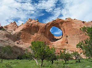
Window skirt
| Window skirt | |
|---|---|
 The "Window Rock" |
|
| Location in County and Arizona | |
| Basic data | |
| State : | United States |
| State : | Arizona |
| County : | Apache County |
| Coordinates : | 35 ° 40 ′ N , 109 ° 4 ′ W |
| Time zone : | Mountain Standard Time ( UTC − 7 ) |
| Residents : | 3,059 (as of: 2000) |
| Population density : | 228.3 inhabitants per km 2 |
| Area : | 34.7 km 2 (approx. 13 mi 2 ) of which 13.4 km 2 (approx. 5 mi 2 ) is land |
| Height : | 2082 m |
| Postal code : | 86515 |
| Area code : | +1 928 |
| FIPS : | 04-83720 |
| GNIS ID : | 0013908 |
Window Rock ( Navajo : Tségháhoodzání ) is a census-designated place in Apache County in the US state of Arizona . Window Rock has 3059 inhabitants on an area of 13 km². The population density is 227.6 / km². Window Rock is also the capital of the Navajo Nation , the self-governing territory of the Navajo Indians who call themselves Diné . It lies at an altitude of 2103 meters above sea level on the Defiance Plateau . Window Rock is served by Arizona State Route 264 .
Web links
Commons : Window Rock, Arizona - Collection of pictures, videos, and audio files
