Wissentrup
|
Wissentrup
City location
Coordinates: 51 ° 59 ′ 6 " N , 8 ° 45 ′ 44" E
|
|
|---|---|
| Height : | 120 m |
| Area : | 2.96 km² |
| Residents : | 635 (Dec. 31, 2009) |
| Population density : | 215 inhabitants / km² |
| Incorporation : | January 1, 1970 |
| Postal code : | 32791 |
| Area code : | 05232 |
|
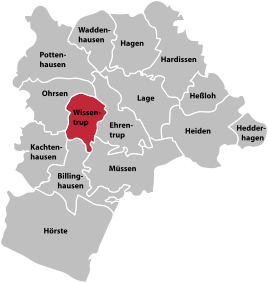
Location of Wissentrup in location
|
|
Wissentrup is a district of the Lippe town of Lage in North Rhine-Westphalia . Until it was incorporated into Lage on January 1, 1970, Wissentrup was an independent municipality.
geography
Protected areas
West and north of the Wissentrup 20 extends hectare large nature reserve " Grutt- and Sunderbach ".
religion
The predominantly Protestant-Reformed population belongs to the parishes in Müssen and Kachtenhausen .
Sports
The largest sports club is the SuS Wissentrup .
traffic
The Wissentrup stop existed in Wissentrup from 1903 . It was on the Lage-Bielefeld railway line between the railway stations in Lage and Ehlenbruch. In the summer of 1960, passenger trains stopped in Wissentrup.
education
There are no educational institutions in Wissentrup and the institutions in the other districts of Lage have to be used.
Individual evidence
- ↑ Martin Bünermann: The communities of the first reorganization program in North Rhine-Westphalia . Deutscher Gemeindeverlag, Cologne 1970, p. 105 .
- ↑ "Grutt- und Sunderbach" nature reserve in the specialist information system of the State Office for Nature, Environment and Consumer Protection in North Rhine-Westphalia
