Wittenberg (Göttingen Forest)
| Wittenberg | ||
|---|---|---|
|
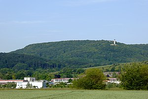
West view of the Wittenberg |
||
| height | 386 m | |
| location | District of Göttingen , Lower Saxony | |
| Mountains | Göttingen Forest | |
| Coordinates | 51 ° 36 '0 " N , 9 ° 58' 15" E | |
|
|
||
| Type | Zeugenberg | |
| rock | Shell limestone | |
The Wittenberg is a 386 m high mountain in the Göttingen Forest in southern Lower Saxony , Germany . It is located directly between the villages of Eddigehausen in the southwest and Reyershausen in the northeast, about four kilometers northeast of the district town of Göttingen .
particularities
The completely wooded mountain (Plesseforst) is the northwesternmost branch of the Göttingen Forest. The mountain is connected to the Ibenberg ( 387.6 m ) on the Muschelkalk plateau via a narrow saddle . Some hiking trails lead across the mountain area to the former ramparts of the Wittenburg , a neighboring vantage point on the Leine valley and the Goethelinde . The ruins of Castle Plesse are located on a south-western mountain spur with a keep over 20 meters high and another tower. The northeastern mountain spur of the Wittenburg is also known as the "Krummer Altar". The rampart fortification of the Wittenburg lies on this mountain spur , which, according to ceramic finds , was dated to the late Hallstatt or early La Tène period.
Individual evidence
- ↑ Map services of the Federal Agency for Nature Conservation ( information )
- ^ Sven Schütte : City and District of Göttingen ( Guide to Archaeological Monuments in Germany , Vol. 17), Chapter Wittenburg . Konrad Theiss Verlag, Stuttgart 1988, p. 251, ISBN 3-8062-0544-2 .

