Volgograd reservoir
| Volgograd reservoir Волгоградское водохранилище |
|||||||||||
|---|---|---|---|---|---|---|---|---|---|---|---|
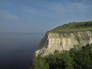
| The Stenka Rasin cliff on the Volgograd reservoir | |||||||||||
|
|||||||||||
|
|
|||||||||||
| Coordinates | 49 ° 7 '31 " N , 44 ° 56' 8" E | ||||||||||
| Data on the structure | |||||||||||
| Construction time: | 1960 | ||||||||||
| Height of the barrier structure : | 47 m | ||||||||||
| Building volume: | 25.932 million m³ | ||||||||||
| Crown length: | 3 974 m | ||||||||||
| Power plant output: | 2 541 MW | ||||||||||
| Data on the reservoir | |||||||||||
| Water surface | 3 117 km² | ||||||||||
| Reservoir length | 540 km | ||||||||||
| Reservoir width | 17 km | ||||||||||
| Storage space | 31,500 million m³ | ||||||||||
The Volgograd Reservoir ( Russian Волгоградское водохранилище / Wolgogradskoje wodochranilishche ) is a reservoir on the Volga in the south of the European part of Russia . It is the lowest part of the so-called Volga-Kama Cascade .
The reservoir extends on the lower Volga for 400 km between Saratov and the dam at Wolschski and is 3,117 km² in size, with 31.5 billion m³ of storage space.
The barrier structure of the dam is a 3974 meter long and up to 47 meter high stone and debris dam . It has a building volume of 25.932 million cubic meters.
In the Volgograd hydropower plant , the dammed water of the reservoir or the Volga generates electricity, which is mainly used in the industrial plants in Volgograd and Wolschski . The river's water is also used for irrigation. Due to the damming of the Volga, most of the typical meadow and mountain bank was flooded with water.
See also
Individual evidence
- ↑ Article Volgograd Reservoir in the Great Soviet Encyclopedia (BSE) , 3rd edition 1969–1978 (Russian)

