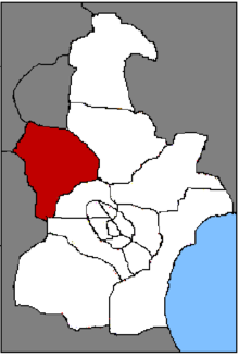
Wuqing
The district of Wuqing ( 武清 区 , Wǔqīng Qū ) belongs to the administrative area of the government- direct city of Tianjin in the People's Republic of China . It is located in the northwest of Tianjin. Wuqing has an area of 1574 km² and around 950,400 inhabitants (end of 2017).
history
Wuqing was originally called Quanzhou (泉州, "source city") and was one of the fortified places with a nominal population of 2500 families on the Gulf of Bohai during the Qin Dynasty (221-207 BC) . In 106 BC BC Emperor Liu Che of the Western Han Dynasty carried out an administrative reform in which China was divided into 13 regions (州). The area of old Quanzhou was divided into two counties : Yongnu County (雍 奴, " marshland ") by the sea and Quanzhou County to the west of it. The seat of the Quanzhou County Government was in today's Huangzhuang Street, and that of Yongnu in today's Wangqingtuo Township. During another administrative reform in 448, during the Northern Wei Dynasty , the two counties were merged again, now under the common name of Yongnu. The administrative seat was relocated to what is now the large municipality of Sicundian.
In 742, during the Tang Dynasty , 110 counties were renamed, the names of which either existed twice or were known by different names. Since “swampland district” didn't sound noble enough, Yongnu was often called “Yongyang” (雍 阳, “sun of harmony”) by local intellectuals. The circle thus fell into the second category of names to be changed and was given the new name “Wuqing”, the short form of 武功 廓清, ie “creating clarity through military success”, an allusion to the strategically important location of the district. The administrative seat of Wuqing County initially remained in Sicundian, but was moved to today's Chengguan Municipality around 1370, at the beginning of the Ming Dynasty , and then to Yangcun Municipality in October 1950, one year after the founding of the People's Republic of China. In 1973 the Wuqing was assigned to the Tianjin City Immediate Government . On June 13, 2000, the State Council of the People's Republic of China decided to disband Wuqing County and transform it into the Wuqing District.
Administrative structure
At the community level, Wuqing is made up of 5 street districts and 24 large communities (as of 2019). These are:
|
|
Web links
- Community website (Chinese)
Individual evidence
- ↑ 区域 概况. In: tjwq.gov.cn. Retrieved July 7, 2019 (Chinese).
- ^ Charles O. Hucker: A Dictionary of Official Titles in Imperial China. Stanford University Press , Stanford 1985, p. 178.
- ↑ On the problem of inadequate drainage , the resulting salinization of the soil and the resulting famine, see Joseph W. Esherick: The Origins of the Boxer Uprising. University of California Press , Berkeley 1987, pp. 2 and 14.
- ↑ 武功 廓清 之 明珠 —— 武清 行 纪. In: 202.204.175.216 [Beijing Foreign Trade University]. August 28, 2014, accessed July 8, 2019 (Chinese).
- ↑ 历史 沿革. In: tjwq.gov.cn. Retrieved July 8, 2019 (Chinese).
Coordinates: 39 ° 23 ' N , 117 ° 3' E
