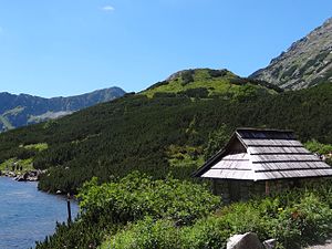
Wyżnia Kopa
| Wyżnia Kopa | ||
|---|---|---|
|
View from the Dolina Pięciu Stawów Polskich valley |
||
| height | 1725 m npm | |
| location | Poland , Lesser Poland | |
| Mountains | High Tatras , Carpathian Mountains | |
| Coordinates | 49 ° 12 '47 " N , 20 ° 2' 43" E | |
|
|
||
The Wyżnia Kopa is a mountain in the massif of miedziane Grań in the Polish Tatra Mountains in the Malopolska province with an elevation of 1725 m npm
Location and surroundings
Below the summit is the Dolina Pięciu Stawów Polskich valley in the south and the Dolina Roztoki valley . The Wyżnia Kopa is located in the west of the massif of miedziane . Its southern slope is only about 60 meters high, while its northern slope is significantly higher. The Niżnia Kopa is located nearby .
etymology
The name Wyżnia Kopa can be translated as Higher Hill .
First ascent
The climb to Wyżnia Kopa is quite easy. It can therefore be assumed that shepherds, miners and poachers have been climbing it since the 17th century at the latest.
tourism
There is no marked hiking trail leading to Wyżnia Kopa .
The Schronisko PTTK w Dolinie Pięciu Stawów Polskich is located at the foot of the massif .
Web links
supporting documents
- Zofia Radwańska-Paryska, Witold Henryk Paryski, Wielka encyklopedia tatrzańska, Poronin, Wyd. Górskie, 2004, ISBN 83-7104-009-1 .
- Tatry Wysokie słowackie i polskie. Mapa turystyczna 1: 25.000, Warszawa, 2005/06, Polkart, ISBN 83-87873-26-8 .

