
Xinyi (Keelung)
|
Xinyi 信義 區 |
|||
 Location of Xinyis in Keelung |
|||
| State : |
|
||
| Coordinates : | 25 ° 8 ' N , 121 ° 46' E | ||
| Area : | 10.6706 km² | ||
| Residents : | 52,463 (September 2018) | ||
| Population density : | 4,917 inhabitants per km² | ||
| Time zone : | UTC + 8 (Chungyuan time) | ||
| Telephone code : | (+886) (0) 2 | ||
| Postal code : | 201 | ||
| ISO 3166-2 : | TW-KEE | ||
| Community type : | Municipality of Keelung | ||
| Website : | |||
|
|||

Xinyi ( Chinese 信義 區 , Pinyin Xìnyì Qū , Pe̍h-ōe-jī Sìn-gī Khu ) is a district of the northern Taiwanese port city of Keelung .
Location and importance
Xinyi is located on the eastern edge of the city of Keelung. It is surrounded by the neighboring districts of Zhongzheng in the north, Ren'ai in the west and Nuannuan in the south. To the east, Xinyi borders the New Taipei City area . The landscape is dominated by hills. Due to its elevated position near the port of Keelung , the place gained strategic importance in the 19th century and was fortified with the Gongziliao fort . The remains of the fort that can be visited today belong to a fortification system built between 1901 and 1908 by the Japanese colonial rulers .
The landscape of Xinyi rises hilly from the nearby sea coast, so that from some viewpoints in Xinyi there are delightful views of the sea, the harbor and the city of Keelung. The most important destination is the Zhongzheng Park , which extends on hills across the border between Xinyi and the port district of Zhongzheng. The 25 m high Guanyin statue in the park overlooking the harbor is considered the highest in Southeast Asia and is a landmark of the city of Keelung.
The Chung Yu Technology Institute is located in Xinyi .

View of Xinyi and the Chung Yu Institute
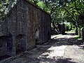
Remains of the Gongziliao fort

Temple archway in Zhongzheng Park

Guanyin statue in Zhongzheng Park


