Yangiyo'l
|
Yangiyoʻl Янгийўл |
||
| Basic data | ||
|---|---|---|
| State : |
|
|
| Province: | Toshkent | |
| Coordinates : | 41 ° 7 ' N , 69 ° 3' E | |
|
|
||
| Height : | 350 m | |
| Residents : | 55,269 (2009) | |
| Postal code : | 102800 | |
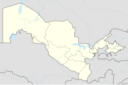
Yangiyoʻl ( Cyrillic Янгийўл ; Russian Янгиюль Jangijul ; until 1934 Каунчи Kauntschi ) is an independent city in the Uzbek province of Tashkent , located about 25 km southwest of the capital Tashkent at about 350 m above sea level. The city is located on the Chirchiq River in the Tashkent oasis between the M34 and M39 motorways and on the Tashkent- Samarkand railway line .
According to the 1989 population census, Yangiyo'l had 58,300 inhabitants at that time, according to a calculation for 2009 the population is 55,269. Between the two world wars, the city developed due to its proximity to Tashkent and the transport links; today it is a center of the food and other light industries.
See also
Individual evidence
- ↑ Page no longer available , search in web archives: bevoelkerungsstatistik.de
- ↑ Yangiyul in the Encyclopædia Britannica

