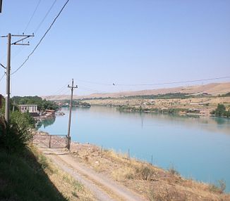
Chirchiq (river)
| Chirchiq | ||
| Data | ||
| location | Tashkent Province ( Uzbekistan ) | |
| River system | Syr Darya | |
| Drain over | Syr Darya → Aral Sea | |
| origin |
Chorvoq Reservoir 41 ° 37 ′ 43 ″ N , 69 ° 57 ′ 55 ″ E |
|
| muzzle |
Syrdarja coordinates: 40 ° 53 '58 " N , 68 ° 42' 31" E 40 ° 53 '58 " N , 68 ° 42' 31" E
|
|
| length | 155 km | |
| Catchment area | 14,900 km² | |
| Discharge at the Chizan gauge ( ⊙ ) A Eo : 14,900 km²
|
MQ 1936/1985 Mq 1936/1985 |
99.2 m³ / s 6.7 l / (s km²) |
| Right tributaries | Ugom | |
| Big cities | Tashkent , Chirchiq | |
| Medium-sized cities | Gazalkent | |
|
Course of the Chirchiq (Чирчик) |
||
The Chirchiq ( Russian Чирчик Chirchik ) is a right tributary of the Syr Darya in Uzbekistan Tashkent Province .
The Chirchiq forms the outflow of the Chorvoq reservoir , which is fed by the Chatkal , Koʻksuv and Piskom rivers. The Ugom flows to him from the right below the dam. In the upper reaches of the Chirchiq flows through a gorge over a distance of 30 km. The Chirchiq runs in a south-westerly direction and passes the town of Gazalkent . In the town of the same name, Chirchiq , part of the water is diverted via the Karasu to the east running Angren River . The Chirchiq touches the megacity of Tashkent on its eastern outskirts and meets the Syr Darja after 155 km. The catchment area of the Chirchiq covers 14,900 km².
Web links
Individual evidence
- ↑ a b Article Chirchiq in the Great Soviet Encyclopedia (BSE) , 3rd edition 1969–1978 (Russian)
- ↑ UNESCO: Chirchik at Chizan (discharge data 1936–1985) ( Memento of the original from August 8, 2014 in the Internet Archive ) Info: The archive link was automatically inserted and has not yet been checked. Please check the original and archive link according to the instructions and then remove this notice.

