
Yaquina Bay Bridge
Coordinates: 44 ° 37 ′ 19 ″ N , 124 ° 3 ′ 23 ″ W.
|
|
||
|---|---|---|
 |
||
| use | Road bridge | |
| Convicted | US Highway 101 | |
| Crossing of | Yaquina Bay ( Yaquina River ) | |
| place | Newport ( Oregon ) | |
| Entertained by | Oregon Department of Transportation | |
| construction | Arch bridge | |
| overall length | 982 meters | |
| Longest span | 183 meters | |
| height | 40.5 meters | |
| building-costs | $ 1,301,016 | |
| start of building | May 3, 1933 | |
| opening | September 6, 1936 | |
| planner | Conde B. McCullough | |
| location | ||
|
||

The Yaquina Bay Bridge is an arch bridge that connects the coastal road on US Highway 101 across Yaquina Bay . It is located south of the city of Newport , Oregon on the west coast of the United States . To the north, the bridge is bordered by Yaquina Bay State Park with the famous Yaquina Bay Lighthouse that can be seen from the bridge.
description
Work on the bridge began on May 3, 1933, with auxiliary bridges being built on both banks. Most of the building material was transported to the coast by rail. The bridge designed by Conde McCullough was opened on September 6, 1936, and the inauguration took place one day earlier on Labor Day . The bridge replaced the previous ferry connection across the bay. In the same year four more bridges designed by him were opened along the Oregon Coast Road. The cost of the Yaquina Bay Bridge then stood at 1,301,016 US dollars after the world economic crisis from the US President Franklin D. Roosevelt created the National Industrial Recovery Act came. A total of $ 5,602,000 was spent on the bridges along Oregon's Coast Route 101. This continuous road connection enabled the economy and tourism on the coast to be intensified.
construction
Around 23,000 m 3 of concrete , 1,123 tons of reinforced steel and 2,065 tons of structural steel were used in the construction of the bridge, and around 220 workers were employed. The bridge has two lanes and pedestrian walkways on either side. The main steel arch has a span of 107 meters and a height of 82 meters above the water. The reinforced concrete pillars of the main arch stand in a water depth of about 18 meters. A concrete platform girder forms the northern girder, a series of 5 steel arches form the southern part of the bridge. In its course, the road has an average gradient of 4 percent. Like many other bridges designed by McCullough, the Yaquina Bay Bridge also has many typical architectural features such as neo-Gothic turrets, Art Deco obelisks or Romanesque arches. The turrets on each of the four sides of the large arch have a passage for pedestrians and serve decorative purposes, the decorative stairs at the north end of the bridge are another stylistic feature.
use
The average daily traffic over the bridge is around 18,000 vehicles (2007). The analysis of the statics by the Oregon Department of Transportation in 2007 showed that the bridge was in a satisfactory to partially unsatisfactory condition. Major renovations worth approximately $ 9.5 million are planned for 2011. In the 2008 film Prom Night , the bridge appears in the opening scene.
gallery

The main arch on the north side

View along the street through the main arch
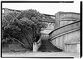
The northern stairs (summer 1990)

Facing south


Web links
Individual evidence
- ^ Ray Bottenberg: Bridges of the Oregon Coast . Arcadia Publishing, 2006, ISBN 0-7385-4860-X , p. 129.
- ↑ a b Dwight A. Smith, Norman, James B .; Dykman, Pieter T .: Historic Highway Bridges of Oregon . Oregon Historical Society Press, 1989, ISBN 0-87595-205-4 , p. 111.
- ^ Robert W. Hadlow: Elegant Arches, Soaring Spans: CB McCullough, Oregon's Master Bridge Builder . Oregon State University Press, 2001, ISBN 0-87071-534-8 , pp. 139.
- ^ Historic American Engineering Record . The Library of Congress. Retrieved July 1, 2010.
- ↑ Sens, Josh. Oregon Coast Bridges. ( Memento of June 25, 2010 in the Internet Archive ) Via, March 2003. (English)
- ↑ Yaquina Bay Bridge Yaquina Bay Bridge on Historic Bridges of the United States
- ↑ ftp://ftp.odot.state.or.us/Bridge/bridge_website_chittirat/2009_Bridge_Condition_Report_web.pdf 2009 Bridge condition report, Oregon Department of Transportation