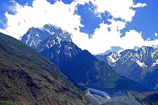
Yarkhun
| Yarkhun | ||
| Data | ||
| location | Khyber Pakhtunkhwa ( Pakistan ) | |
| River system | Indus | |
| Drain over | Mastuj → Kunar → Kabul → Indus → Indian Ocean | |
| origin |
Chiantar Glacier 36 ° 48 ′ 47 ″ N , 73 ° 33 ′ 46 ″ E |
|
| Source height | approx. 3700 m | |
| Association with |
Laspur to Mastuj Coordinates: 36 ° 17 ′ 3 ″ N , 72 ° 30 ′ 8 ″ E 36 ° 17 ′ 3 ″ N , 72 ° 30 ′ 8 ″ E |
|
| Mouth height | approx. 2300 m | |
| Height difference | approx. 1400 m | |
| Bottom slope | approx. 11 ‰ | |
| length | 130 km | |
| Small towns | Mastuj | |
The Yarkhun is the right source river of the Mastuj in the Pakistani province of Khyber Pakhtunkhwa .
The Yarkhun arises at the glacier mouth of the Chiantar glacier . From there it flows in a south-westerly direction through the mountains of the Chitral district . A country road follows the course of the river for the lower 90 km. In the small town of Mastuj , the Laspur meets the Yarkhun from the left and unites with it to form Mastuj. The Yarkhun has a length of 130 km. The Yarkhun river valley forms the dividing line between Hinduraj in the east and the Hindu Kush in the west and north.
Web links
Commons : Yarkhun - collection of pictures, videos and audio files
