
Zaroumbey Darey
Location of Zaroumbey Darey in Niger |

Zaroumbey Darey (also: Zaroumdareye , Zerma Daré ) is a village in the rural community of Tondikiwindi in Niger .
geography
The village, led by a traditional chief (chef traditionnel) , is located around 56 kilometers northwest of the main town of Tondikiwindi in the rural community of the same name, which belongs to the Ouallam department in the Tillabéri region. The state border with Mali is about 44 kilometers north of Zaroumbey Darey. Tchioma Bangou in the southeast is one of the larger villages in the vicinity of Zaroumbey Darey .
story
More than 2500 people from Zaroumbey Darey and the surrounding hamlets fled to Mangaïzé , located in the same rural community, in the summer of 2020 because of the unsafe situation . This was preceded by kidnappings, looting, murders and death threats by armed groups. At least 100 civilians were killed in an Islamist attack on the neighboring villages of Zaroumbey Darey and Tchioma Bangou on January 2, 2021. Around 30 people were killed in Zaroumbey Darey. The attack occurred a few days after the parliamentary elections and the first round of the presidential elections in Niger.
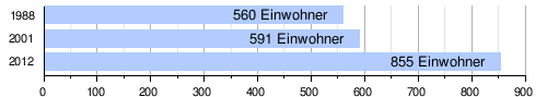
population
At the 2012 census, Zaroumbey Darey had 855 inhabitants who lived in 74 households. At the 2001 census, the population was 591 in 61 households, and at the 1988 census, the population was 560 in 57 households.
Individual evidence
- ↑ a b National Repertoire des Localités (ReNaLoc). (RAR) Institut National de la Statistique de la République du Niger, July 2014, p. 491 , accessed on 7 August 2015 (French).
- ↑ Niger: Rapport d'Evaluation Rapide de Protection Site de Mangaizé, commune rurale de Tondikiwindi. United Nations Office for the Coordination of Humanitarian Affairs , August 28, 2020, accessed January 3, 2021 (French).
- ↑ tagesschau.de: Attack in Niger: the number of dead rises to more than 100. Accessed on January 3, 2021 .
- ↑ Au moins 70 civils tués au Niger in des attaques de villages. In: RTS. January 2, 2021, accessed January 3, 2021 (French).
- ↑ At least 70 fatalities in a serious attack in Niger. In: derStandard.at. January 2, 2021, accessed January 3, 2021 .
- ^ Répertoire National des Communes (RENACOM). (RAR file) Institut National de la Statistique, accessed November 8, 2010 (French).
- ↑ Recensement Général de la Population 1988: Répertoire National des Villages du Niger . Bureau Central de Recensement, Ministère du Plan, République du Niger, Niamey March 1991, p. 248 ( web.archive.org [PDF; accessed May 4, 2019]).
Coordinates: 14 ° 54 ' N , 1 ° 47' E