Tender joke
|
Tender joke
Rechlin parish
Coordinates: 53 ° 22 ′ 19 ″ N , 12 ° 50 ′ 28 ″ E
|
|
|---|---|
| Height : | 63 m above sea level NHN |
| Area : | 4.99 km² |
| Postal code : | 17248 |
| Area code : | 039823 |
|
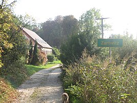
Entrance to Zartwitz
|
|
Zartwitz is a district of the municipality of Rechlin in the Mecklenburg Lake District ( Office Röbel-Müritz in Mecklenburg-Western Pomerania ).
geography
The place is located in the Müritz sub-area of the Müritz National Park on the eastern bank of the Woterfitzsee , eight kilometers northeast of Rechlin and 20 kilometers southeast of Waren (Müritz) at an altitude of about 60-70 m above sea level. NHN . To the east of the place there is a large forest area and in this the Röthsee . To the north there are four fish pond basins separated by dams. Zartwitz itself consists of two built-up squares about 800 meters apart. The Zartwitzer Hütte settlement is located 1.4 kilometers north of Zartwitz in a forest clearing on the Landsee .
history
The village is mentioned for the first time in the Mirow register of 1654. At the beginning of the 18th century, Zartwitz consisted of a princely Meierhof, which was provided with clamping services from the districts of Granzin, Kakeldütt and Blankenförde. 1780 is reported about a glassworks, which is considered to give the district Zartwitzer Hütte its name. From 1910, the Mecklenburg roof and flat tile factory was built on the banks of the Woterfitzsee . In 1935 the village was abandoned in the course of the construction of the Rechlin test site and the residents evacuated.
During the GDR era, the LPG Retzow built and maintained a holiday camp for the children of their cooperative farmers on the east bank of the Woterfitzsee . After 1990 it was left to decay and demolished in 2010 by the national park administration.
There is a holiday center in the village with guest houses and row bungalows, which has not been used for a few years and is empty.
Web links
- Zartwitz in the historical directory of the association for computer genealogy
Individual evidence
- ↑ Geoportal. Mecklenburg Lake District - Lower Surveying and Geoinformation Authority, March 31, 2016, accessed on August 11, 2018 .

