
Sifnos and Päijänne Water Tunnel: Difference between pages
ce |
|||
| Line 1: | Line 1: | ||
[[Image:Päijännetunneli.png|thumb|250px|Map of the Päijänne Water Tunnel.<br />'''1.''' Asikkalanselkä<br />'''2.''' Kalliomäki water distribution station<br />'''3.''' Korpimäki water pump station<br/>'''4.''' Artificial lake of Silvola ]] |
|||
{{Infobox Greek Isles |
|||
|name = Sifnos |
|||
|native_name = Σίφνος |
|||
|skyline = Kastro chapell.jpg |
|||
|sky_caption = Chapel below Kastro |
|||
|map = GR_Sifnos.PNG |
|||
|coordinates = {{coord|36|59|N|24|40|E}} |
|||
|chain = Cyclades |
|||
|isles = |
|||
|area = 73.942 |
|||
|highest_mount = |
|||
|elevation = 679 |
|||
|periph = [[South Aegean]] |
|||
|prefect = [[Cyclades]] |
|||
|capital = Apollonia |
|||
|population = 2442 |
|||
|pop_as_of = 2001 |
|||
|postal = 840 03 |
|||
|telephone = 22840 |
|||
|license = ΕΜ |
|||
|website = [http://www.sifnos.gr/ www.sifnos.gr] |
|||
}} |
|||
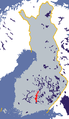
The '''Päijänne Water Tunnel''' ({{Lang-fi|'''Päijännetunneli'''}}), located in [[Southern Finland]], is the world's longest continuous [[rock (geology)|rock]] [[tunnel]]. It is 120 [[kilometer]]s (75 [[mile]]s) long and runs 30–100 [[meter]]s under the surface in [[bedrock]]. The purpose of the tunnel is to provide [[fresh water]] for more than a million people in Southern Finland in the cities of [[Helsinki]], [[Espoo]], [[Vantaa]], [[Hyvinkää]], [[Järvenpää]], [[Kerava]], [[Kauniainen]], [[Kirkkonummi]], [[Sipoo]], and [[Tuusula]]. The former Porvoo Rural Municipality, now merged with the municipality of [[Porvoo]], also took part in the building of the scheme but has never drawn water from it for domestic use. |
|||
'''Sifnos''' ({{lang-el|Σίφνος}}) is an island [[Communities and Municipalities of Greece|municipality]] in the [[Cyclades]] island group in [[Greece]]. The main town on the island is known as Apollonia (pop. 942) located near the center of the island. The second-largest town is Artemon (744). Another major population center is the hilltop village named Kastro (101), built on top of a high cliff on its northwestern shore. The port settlement, on the west cost of the island is known as Kamares (188). |
|||
The tunnel starts at [[Asikkalanselkä]] in [[Lake Päijänne]], which is the second largest lake in [[Finland]], with an area of about 1080 km². The tunnel slopes slightly downhill so that water flows naturally. Water from the southern portion of Lake Päijänne is of rather good quality at the [[Water tunnel (physical infrastructure)|water tunnel]] intake and is usually drinkable without processing. The tunnel ends at the [[artificial lake]] of Silvola in Vantaa in the [[Greater Helsinki]] area. From the artificial lake, water is pumped to water treatment plants in [[Pitkäkoski]] and [[Vanhakaupunki]], but the constant temperature in the deep tunnel ensures high quality during transport, so only minimal processing is required before use. |
|||
==Geography== |
|||
Sifnos lies in the less touristed western half of the Cyclades between [[Serifos]] and [[Milos]] and is also located west of [[Delos]] and [[Paros]] and is about 130 km (80 nautical miles) from [[Piraeus]] ([[Athens]]' port). It has an area of 74 km² and is 15 km long and 7.5 km wide. and a shoreline of 70 km, with a permanent population of 2442. The island is reached on the ferries which run on the Piraeus- Kythnos- Serifos- Sifnos- Milos- Kimolos line. There are also infrequent sailings to other islands in the Cyclades. |
|||
Tunnel construction started in [[1972]] and was completed in [[1982]] at a cost of about 200 million [[euro]]s (adjusted for inflation).<ref>{{cite web|url=http://www.helsinginvesi.fi/paijanne/alltypes.asp?menu_id=70|title=Yleistä Päijänne-tunnelista|publisher=Helsingin vesi|language=Finnish|accessdate=2008-10-12}}</ref> In [[2001]], portions of the tunnel required repair due to rock falls. In 2008, the tunnel is undergoing an extensive renovation. The southern part of the tunnel is being reinforced in order to prevent [[cave-in]]s. During the renovation, from [[April 15]] to [[December 31]], [[2008]], the raw water for the [[Greater Helsinki]] metropolitan area is being drawn from the [[Vantaanjoki|Vantaa River]]. |
|||
==History== |
|||
The tunnel has a cross section of 16 m² (wide enough for a truck) and enables a water flow of 10 m³/s. At current water usage rates, treatment plants take water at a rate of about 3.1 m³/s for drinking water processing. The tunnel can be used as an emergency water reserve during water supply disruption. |
|||
In 1400 BC the island of Sifnos becomes primarily inhabited by Greeks. This migration was caused by the tremendous volcanic explosion on the island of Santorini, which destroyed many major centers of Minoan civilization. |
|||
In the 8th century BC, the island of Sifnos was plundered by Samian pirates. The mines were not producing precious metals any more, so the pirates left and the island was reduced to poverty. |
|||
Sifnos was very wealthy in ancient times, thanks to its gold and silver mines. Proof of this, is the treasury which the Siphnians built at Delphi in the 6th century BC to house their offerings. However, it appears that something went wrong with the mines; either they were worked out or flooded by the sea -we do not know which- and their production ceased. |
|||
Due to the physiology of the island (rich [[clay]] veins, sunny weather and temperature) Sifnos has been traditionally the capital of [[pottery]] in the [[Aegean Sea|Aegean]], with unique jars and pots that are a kind of "trademark" of the island. They are frequent the Sifnian everyday life, such as [[ashtray]]s, cooking and food vessels, "masteles", "foufoudes" (kind of chimneys) etc. Locally, 'Sifnios' was a variant word for [[potter]]. Initially the oldest potteries were found in central regions such as Artemon and Ano Petali to avoid [[pirate]] attacks. |
|||
==Historical population== |
|||
{| border="1" cellpadding="2" cellspacing="0" |
|||
|- bgcolor="#efefef" |
|||
! Year !! Communal population !! Change !! Island population !! Change |
|||
|- |
|||
| 1981 || - || - || - || - |
|||
|- |
|||
| 1991 || - || 103 || 1,960 || - |
|||
|- |
|||
| 2001 || - || - || 2,442 || +482/+24.59% |
|||
|} |
|||
==Communities== |
|||
*[[Apollonia (Sifnos), Greece|Apollonia]] |
|||
*[[Artemonas]] |
|||
*[[Faros (Sifnos), Greece|Faros]] |
|||
*[[Kastro (Sifnos), Greece|Kastro]] |
|||
*[[Platys Gialos (Sifnos), Greece|Platys Gialos]] |
|||
*'''Sifnos''', also '''Kamares Sifnou''' |
|||
*[[Vathy (Sifnos), Greece|Vathy]] |
|||
*[[Herronisos (Sifnos), Greece|Herronisos]] |
|||
__NOTOC__ |
|||
==Gallery== |
==Gallery== |
||
<gallery> |
<gallery> |
||
Image:Päijänne.png|Location of [[Lake Päijänne]] in [[Finland]]. |
|||
Image:Apollonia on Sifnos.jpg|Apollonia |
|||
Image:Silvolan tekojärvi 1.jpg|The artificial lake of [[Silvola]], where the Päijänne Water Tunnel ends. |
|||
Image:Vathy_harbour_Greek_island_of_Sifnos.jpg| The church at Vathy |
|||
</gallery> |
</gallery> |
||
==See also== |
==See also== |
||
*[[ |
*[[List of further tunnels by length]] |
||
==References== |
==References== |
||
| Line 73: | Line 23: | ||
==External links== |
==External links== |
||
*[http://www.mtry.org/eng_html/eng_tekniset_tilat.htm Finnish Tunnelling Association, Päijänne Water Tunnel] |
|||
*[http://www.sifnos.gr/ Official website] {{en}} {{el icon}} |
|||
*[http://www.psv-hrv.fi Pääkaupunkiseudun Vesi Oy] |
|||
*'''Map and aerial photos''': |
|||
**Street map: [http://www.mapquest.com/maps/map.adp?latlongtype=decimal&latitude=24.667&longitude=-36.9855&zoom=6 Street map from Mapquest], [http://maps.msn.com/map.aspx?&lats1=24.667&lons1=-36.9845&alts1=35 MapPoint] or [http://maps.google.com/maps?||=36.9845,24.667 Google] |
|||
**Satellite images: [http://maps.google.com/maps?ll=36.9845,24.667&spn=0.11,0.18&t=k Google] - image not yet available |
|||
*Coordinates: {{coord|36|59|5|N|24|40|5|E|region:GR}} |
|||
{{The Cyclades}} |
|||
{{Cyclades}} |
|||
{{Aegean Sea}} |
|||
{{DEFAULTSORT:Paijanne Water Tunnel}} |
|||
[[Category:Cities and towns in Greece]] |
|||
[[Category: |
[[Category:Water tunnels]] |
||
[[Category: |
[[Category:Water supply and sanitation in Finland]] |
||
[[Category: |
[[Category:Tunnels in Finland]] |
||
[[fr:Aqueduc du Päijänne]] |
|||
[[ca:Sifnos]] |
|||
[[ |
[[lt:Peijenės tunelis]] |
||
[[ |
[[fi:Päijännetunneli]] |
||
[[ |
[[sv:Päijännetunneln]] |
||
[[el:Σίφνος]] |
|||
[[es:Sifnos]] |
|||
[[fr:Sifnos]] |
|||
[[gl:Sifnos - Σίφνος]] |
|||
[[it:Sifnos]] |
|||
[[he:סיפנוס]] |
|||
[[la:Siphnos]] |
|||
[[nl:Sifnos]] |
|||
[[ja:シフノス島]] |
|||
[[nn:Sífnos]] |
|||
[[pl:Sifnos]] |
|||
[[sr:Сифнос]] |
|||
[[sh:Sifnos]] |
|||
[[sv:Sifnos]] |
|||
[[zh:锡弗诺斯岛]] |
|||
Revision as of 17:28, 12 October 2008

1. Asikkalanselkä
2. Kalliomäki water distribution station
3. Korpimäki water pump station
4. Artificial lake of Silvola
The Päijänne Water Tunnel (Finnish: Päijännetunneli), located in Southern Finland, is the world's longest continuous rock tunnel. It is 120 kilometers (75 miles) long and runs 30–100 meters under the surface in bedrock. The purpose of the tunnel is to provide fresh water for more than a million people in Southern Finland in the cities of Helsinki, Espoo, Vantaa, Hyvinkää, Järvenpää, Kerava, Kauniainen, Kirkkonummi, Sipoo, and Tuusula. The former Porvoo Rural Municipality, now merged with the municipality of Porvoo, also took part in the building of the scheme but has never drawn water from it for domestic use.
The tunnel starts at Asikkalanselkä in Lake Päijänne, which is the second largest lake in Finland, with an area of about 1080 km². The tunnel slopes slightly downhill so that water flows naturally. Water from the southern portion of Lake Päijänne is of rather good quality at the water tunnel intake and is usually drinkable without processing. The tunnel ends at the artificial lake of Silvola in Vantaa in the Greater Helsinki area. From the artificial lake, water is pumped to water treatment plants in Pitkäkoski and Vanhakaupunki, but the constant temperature in the deep tunnel ensures high quality during transport, so only minimal processing is required before use.
Tunnel construction started in 1972 and was completed in 1982 at a cost of about 200 million euros (adjusted for inflation).[1] In 2001, portions of the tunnel required repair due to rock falls. In 2008, the tunnel is undergoing an extensive renovation. The southern part of the tunnel is being reinforced in order to prevent cave-ins. During the renovation, from April 15 to December 31, 2008, the raw water for the Greater Helsinki metropolitan area is being drawn from the Vantaa River.
The tunnel has a cross section of 16 m² (wide enough for a truck) and enables a water flow of 10 m³/s. At current water usage rates, treatment plants take water at a rate of about 3.1 m³/s for drinking water processing. The tunnel can be used as an emergency water reserve during water supply disruption.
Gallery
-
 Location of Lake Päijänne in Finland.
 -
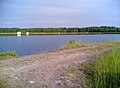 The artificial lake of Silvola, where the Päijänne Water Tunnel ends.


See also
References
- ^ "Yleistä Päijänne-tunnelista" (in Finnish). Helsingin vesi. Retrieved 2008-10-12.