
Kyle Weaver and Ocieka: Difference between pages
No edit summary |
|||
| Line 1: | Line 1: | ||
{{Infobox |
{{Infobox Settlement |
||
| name |
| name = Ocieka |
||
| image_skyline = House_in_Ocieka.JPG |
|||
| nickname = |
|||
| image_caption = ''Traditional House in Ocieka Village'' |
|||
| image = Replace this image male.svg |
|||
| settlement_type = Village |
|||
| caption = |
|||
| |
| total_type = |
||
| |
| image_flag = |
||
| image_shield = |
|||
| weight_lb = 201 |
|||
| image_map = |
|||
| position = [[Guard (basketball)|Guard]] |
|||
| subdivision_type = [[Countries of the world|Country]] |
|||
| birth_date = {{birth date and age|1986|2|18}} |
|||
| subdivision_name = {{POL}} |
|||
| birth_place = [[Beloit, Wisconsin]] |
|||
| subdivision_type1 = [[Voivodeships of Poland|Voivodeship]] |
|||
| highschool = [[Beloit Memorial High School]] |
|||
| subdivision_name1 = [[Image:POL_wojew%C3%B3dztwo_podkarpackie_flag.svg|22px]] [[Subcarpathian Voivodeship|Subcarpathian]] |
|||
| college = [[Washington State University|Washington State]] |
|||
| subdivision_type2 = [[Powiat|County]] |
|||
| league = [[National Basketball Association|NBA]] |
|||
| subdivision_name2 = [[Image:POL_powiat_ropczycko-sędziszowski_flag.svg|22px]] [[Ropczyce-Sędziszów County|Ropczyce-Sędziszów]] |
|||
| team = [[Oklahoma City Thunder]] |
|||
| subdivision_type3 = [[Gmina]] |
|||
| ⚫ | |||
| |
| subdivision_name3 = [[Gmina Ostrów|Ostrów]] |
||
| latd = 50 |
|||
| draft = second round, 38th overall |
|||
| ⚫ | |||
| draft_team = [[Charlotte Bobcats]] |
|||
| |
| lats = |
||
| |
| latNS = N |
||
| |
| longd = 21 |
||
| |
| longm = 35 |
||
| |
| longs = |
||
| longEW = E |
|||
}} |
|||
| pushpin_map = Poland |
|||
'''Kyle Donovan Weaver''' (born [[February 18]], [[1986]]) is an [[United States|American]] [[basketball]] player. He played [[college basketball]] for [[Washington State University]], and was drafted 38th overall by the [[Charlotte Bobcats]] in the [[2008 NBA Draft]]. He was born in [[Beloit, Wisconsin]]. |
|||
| pushpin_label_position = bottom |
|||
| elevation_m = |
|||
| population_total = 1233 |
|||
| website = }} |
|||
'''Ocieka''' {{IPA-pl|[|o|'|ć|e1|k|a|]}} is a [[village]] in the administrative district of [[Gmina Ostrów]], within [[Ropczyce-Sędziszów County]], [[Subcarpathian Voivodeship]], in south-eastern [[Poland]]. It lies approximately {{convert|6|km|mi|0}} north of [[Ostrów, Ropczyce-Sędziszów County|Ostrów]], {{convert|7|km|mi|0|abbr=on}} north-west of [[Ropczyce]], and {{convert|33|km|mi|0|abbr=on}} west of the regional capital [[Rzeszów]].<ref name="TERYT">''{{cite web |url=http://www.stat.gov.pl/broker/access/prefile/listPreFiles.jspa |title=Central Statistical Office(GUS) - TERYT(National Register of Territorial Land Apportionment Journal) |date=01.09.2008|language=Polish}}''</ref> |
|||
On [[August 11]], [[2008]], he was traded to the [[Oklahoma City Thunder|Oklahoma City National Basketball Association team]] for a second-round pick from the [[2009 NBA Draft]], which originally belonged to the [[New Jersey Nets]].<ref>[http://www.nba.com/bobcats/weaver_trade_080811.html Bobcats Acquire 2009 Second-Round Draft Pick]</ref> |
|||
''(Between [[1975]]-[[1998]] Ocieka was in the [[Rzeszów Voivodeship]])''. The village has a population of 1,233 and lies on the main road between [[Ropczyce]] and [[Mielec]]. It is situated in the [[Sandomierz Wilderness]] ([[Polish]]: ''Puszcza Sandomierska''), one of the biggest forests in southern [[Poland]], which covers large parts of the [[Sandomierz Basin]], an areas was once popular with [[Szlachta|Polish nobility]] ([[Polish]]: ''Szlachta'') for hunting and fishing. Ocieka lies on the [[Tuszymka|Tuszymka river]], a tributary of the [[Wisłoka|Wisłoka river]]. In the past this area was known for [[iron]] [[smelting]] and [[iron]] goods.<ref>''Kłos, Stanisław. “Wojewodztwo Rzeszowskie Prewodnik″, <small>page 176 [[copyright|©]] Sport i Turystyka, 1969.</small></ref> |
|||
| ⚫ | |||
== History == |
|||
Since it's formation in the late [[15th century|15<sup><small>th</small></sup> century]] Ocieka has been known by several different names, although these appear to be [[phonetics|phonetic]] variations of the same name. Parish documents and chronicles show it as ''‘Otsijeka’'', ''‘Odszycha’'' and ''‘Ucieka’''.<ref>''Bociek, Jan. “Parafia św. Katarzyny Aleksandryjskiej PM w Ociece”<small>[[copyright| ©]] 2007.[http://jbociek.webpark.pl/strony/ocieka.html| (''Website in Polish'')]''</small></ref> The village was named by Anna ''née Ocieska'' Mielecka and it is probably the ancestral seat of the ''‘Ocieskis’'', who also owned [[Rzemień, Subcarpathian Voivodeship|Rzemień]], a village to the north of Ocieka.<ref>''Source: “Slownik Geograficzny Królestwa Polskiego” - Warsaw <small>(1886, vol. 7, page 370)[http://dir.icm.edu.pl/pl/Slownik_geograficzny/]''</small></ref> |
|||
According to a local legend, in the region near Ocieka there occurred a battle against the [[Tatar]]s. The Polish Knights achieved a resounding victory. To commemorate this, an area close by became known as ''‘Góra Tatarska’'' (Tatar Hill).<ref>''Bociek, Jan. “Parafia św. Katarzyny Aleksandryjskiej PM w Ociece”<small>[[copyright| ©]] 2007.[http://jbociek.webpark.pl/strony/ocieka.html| (''Website in Polish'')]''</small></ref> In 1531 the Grand Crown Hetman, [[Jan Tarnowski|Jan Amor Tarnowski]] led a [[Polish army]] against [[Moldavia|Moldavian]] [[Prince]] (''‘Hospodar’'') [[Petru Rareş]] |
|||
in the [[Battle of Obertyn]]. Despite being outnumbered four to one, the battle ended with a [[Polish]] victory, a complete [[Tatar]] [[surrender]], and the reconquest of [[Pokutia]]. [[Jan Tarnowski|Tarnowski]] brought his [[Tatar]] [[prisoner of war|prisoners-of-war]] back to Ocieka. These [[prisoner of war|prisoners]] became the first occupants of a new settlement near Ocieka called [[Sadykierz, Ropczyce-Sędziszów County|‘Sadykierz’]]. The name [[Sadykierz, Ropczyce-Sędziszów County|Sadykierz]] has distinct [[Tatar]] origins, just as do today's inhabitants of the same village (''The settlement of [[Sadykierz]] was located by a [[glacial period|post-glacial]] [[lake]], home to a rare species of white [[nymphaeaceae|water-lily]].'')<ref>''Bociek, Jan. “Parafia św. Katarzyny Aleksandryjskiej PM w Ociece”<small>[[copyright| ©]] 2007.[http://jbociek.webpark.pl/strony/ocieka.html| (''Website in Polish'')]''</small></ref> |
|||
Ocieka became an independent parish in [[1610]]. At this time, Ocieka had a very [[industrial]] character; [[charcoal|wood charcoal]] was manufactured here, as was [[iron]]. In the [[17th century|17<sup><small>th</small></sup>]] and [[18th century|18<sup><small>th</small></sup> centuries]] there was a [[glass]] [[foundry]] nearby. |
|||
At this time the ownership of the village passed from the ‘Ocieski’ family to the ‘Romerów’ family.<ref>''Bociek, Jan. “Parafia św. Katarzyny Aleksandryjskiej PM w Ociece”<small>[[copyright| ©]] 2007.[http://jbociek.webpark.pl/strony/ocieka.html| (''Website in Polish'')]''</small></ref> |
|||
{{cquote|''“'''Ocieka''', with Wola Ocieska and Zadzikierz, a village on the stream Ocieka or Ociecki, in the [[powiat|county]] ([[powiat|‘powiat’]]) of [[Ropczyce]], lies in a sandy lowland (206 meters). To the north it is surrounded by a large pine forest, the southern part of which is called ‘Spalony las′ (‘burnt forest′), the northern part ‘Sokolny las′ (‘falcon forest′); to the east is the forest of the village of [[Kamionka, Ropczyce-Sędziszów County|Kamionka]], and to the south part of the forests of the village of [[Ostrów, Ropczyce-Sędziszów County|Ostrów]], ‘Duży las′ (‘large forest′), Saszczyński and Sarni (‘deer's’) las. In the middle of the village, near the church, runs the Kolbuszowa-Ropczyce highway, from which a branch runs west, and in [[Dąbie, Subcarpathian Voivodeship|Dąbie]] (8 km. away) on the [[Wisłoka]] river, it joins the main highway from [[Rzochów]] to [[Dębica]]. The outlying settlement of Zadzikierz lies to the northeast (3 km), near the forest on the northeast flank of a hill (245 meters) (this now appears to be the place now called [[Sadykierz, Ropczyce-Sędziszów County|Sadykierz]]). Wola Ocieska (today called [[Wola Ociecka]]), which has a beautiful [[manor house]], is northwest of Ocieka, on the road to [[Dąbie, Subcarpathian Voivodeship|Dąbie]], on the northwest flank of the wooded Łysa górka (211 meters). Between Ocieka and Zadzikierz there are four small ponds, and on the stream a [[watermill]] and a [[windmill]].”'' ''<ref>''Source: “Slownik Geograficzny Królestwa Polskiego” - Warsaw <small>(1886, vol. 7, page 370)[http://dir.icm.edu.pl/pl/Slownik_geograficzny/]''</small></ref><ref>''Kłos, Stanisław. “Wojewodztwo Rzeszowskie Prewodnik″, <small>page 176 [[copyright|©]] Sport i Turystyka, 1969.</small></ref> ''}} |
|||
{{cquote|''“With these outlying settlements the village has 1,465 [[Roman Catholic Church|Roman Catholic]] inhabitants, of whom 127 live on the grounds of the major estate, owned by [[Count]] Władyslaw Romer. The major estate has 756 [[morgen|mórgs]] of farmland <small>(1 [[morgen|mórg]] ≈ 0.56 [[Hectare|ha]])</small>, 52 of meadows and gardens, 89 of pastures, and 1,678 of forests; the minor estate has 1,948 [[morgen|mórgs]] of farmland, 388 of meadows, 479 of pastures, and 343 of forests. The pastures are mostly sandy waste-land. The parish church is old and made of wood, of unknown funding, and it has sacramental registers only from [[1785]]. The parish includes [[Blizna]], with 233 inhabitants; there are 37 [[Jew|Jews]] in the parish. There is a people's school here, and a fund for the poor, which has 500 [[Polish złoty|zł.]] in [[Austrians|austrian]] currency.”'' ''<ref>''Source: “Slownik Geograficzny Królestwa Polskiego” - Warsaw <small>(1886, vol. 7, page 370)[http://dir.icm.edu.pl/pl/Slownik_geograficzny/]''</small></ref>'' |
|||
''“The Reverend [[Franciszek Siarczyński]] (in a manuscript in the [[Ossolineum|Ossolineum library]], N°. 1826), says that this village belonged to [[Rzemień, Subcarpathian Voivodeship|Rzemień]] and that Anna née Ocieska Mielecka named it, but adds that it is probably the ancestral seat of the Ocieskis, who also owned [[Rzemień, Subcarpathian Voivodeship|Rzemień]]. The villages nearest Ocieka are, to the east, [[Zdżary]] and [[Kamionka, Ropczyce-Sędziszów County|Kamionka]], to the south [[Ostrów, Ropczyce-Sędziszów County|Ostrów]], to the west [[Pustków-Krownice|Pustków-Krownice]] and [[Dąbie, Subcarpathian Voivodeship|Dąbie]], to the north [[Blizna]].”'' ''<ref>''Source: “Slownik Geograficzny Królestwa Polskiego” - Warsaw <small>(1886, vol. 7, page 370)[http://dir.icm.edu.pl/pl/Slownik_geograficzny/]''</small></ref>'' <small>''(extracts translated from the [[1886]] edition of [http://dir.icm.edu.pl/pl/Slownik_geograficzny/ ‘Słownik Geograficzny Królestwa Polskiego’)]''</small>}} |
|||
==External links== |
|||
*''{{cite web |url=http://spuscizna.org/spuscizna/ocieka.html |title=The Parish of Ocieka |language=English}}'' |
|||
| ⚫ | |||
*''{{cite web |url=http://www.stat.gov.pl/gus/45_655_PLK_HTML.htm |title=Polish official population figures 2007 |date=31.07.2007|language=Polish}}'' |
|||
*''{{cite web |url=http://dir.icm.edu.pl/pl/Slownik_geograficzny/ |title=Słownik geograficzny Królestwa Polskiego|date=1880-1914|language=Polish}} <small>A publication now in the [[public domain]].</small>'' |
|||
{{reflist}} |
{{reflist}} |
||
==Gallery== |
|||
{{Oklahoma City Thunder current roster}} |
|||
<gallery style="margin:2px auto; text-align:center"> |
|||
{{2008 NBA Draft}} |
|||
Image:Church_Ocieka.JPG|''Church of Saint Catherine in Ocieka''</center> |
|||
Image:Church_Ocieka_2.jpg|''Church of Saint Catherine in Ocieka''</center> |
|||
Image:Shrine_to_the_Virgin_Mary.JPG|''Shrine to the Virgin Mary in Ocieka''</center> |
|||
Image:Cemetary_in_Ocieka.JPG|''Cemetery in Ocieka''</center> |
|||
</gallery> |
|||
<br> |
|||
{{Gmina Ostrów}} |
|||
<small> |
|||
{{Subcarpathian-geo-stub}} |
|||
{{Poland-stub}} |
|||
{{Ropczyce-Sędziszów-geo-stub}} |
|||
{{1911}} |
|||
</small> |
|||
{{coord|50|8|N|21|35|E|region:PL_type:city|display=title}} |
|||
[[Category:Villages in Ropczyce-Sędziszów County|Ocieka]] |
|||
{{BD|1986||Weaver, Kyle}} |
|||
[[Category:American basketball players]] |
|||
[[Category:Washington State Cougars men's basketball players]] |
|||
[[Category:Charlotte Bobcats draft picks]] |
|||
[[Category:Oklahoma City Thunder players]] |
|||
[[Category:People from Beloit, Wisconsin]] |
|||
[[Category:Shooting guards]] |
|||
{{1980s-US-basketball-bio-stub}} |
|||
[[ |
[[pl:Ocieka]] |
||
Revision as of 01:45, 14 October 2008
Ocieka | |
|---|---|
Village | |
 Traditional House in Ocieka Village | |
| Country | |
| Voivodeship | |
| County | |
| Gmina | Ostrów |
| Population | 1,233 |
Ocieka Polish pronunciation: [[] is a village in the administrative district of Gmina Ostrów, within Ropczyce-Sędziszów County, Subcarpathian Voivodeship, in south-eastern Poland. It lies approximately 6 kilometres (4 mi) north of Ostrów, 7 km (4 mi) north-west of Ropczyce, and 33 km (21 mi) west of the regional capital Rzeszów.[1] (Between 1975-1998 Ocieka was in the Rzeszów Voivodeship). The village has a population of 1,233 and lies on the main road between Ropczyce and Mielec. It is situated in the Sandomierz Wilderness (Polish: Puszcza Sandomierska), one of the biggest forests in southern Poland, which covers large parts of the Sandomierz Basin, an areas was once popular with Polish nobility (Polish: Szlachta) for hunting and fishing. Ocieka lies on the Tuszymka river, a tributary of the Wisłoka river. In the past this area was known for iron smelting and iron goods.[2]
History
Since it's formation in the late 15th century Ocieka has been known by several different names, although these appear to be phonetic variations of the same name. Parish documents and chronicles show it as ‘Otsijeka’, ‘Odszycha’ and ‘Ucieka’.[3] The village was named by Anna née Ocieska Mielecka and it is probably the ancestral seat of the ‘Ocieskis’, who also owned Rzemień, a village to the north of Ocieka.[4]
According to a local legend, in the region near Ocieka there occurred a battle against the Tatars. The Polish Knights achieved a resounding victory. To commemorate this, an area close by became known as ‘Góra Tatarska’ (Tatar Hill).[5] In 1531 the Grand Crown Hetman, Jan Amor Tarnowski led a Polish army against Moldavian Prince (‘Hospodar’) Petru Rareş in the Battle of Obertyn. Despite being outnumbered four to one, the battle ended with a Polish victory, a complete Tatar surrender, and the reconquest of Pokutia. Tarnowski brought his Tatar prisoners-of-war back to Ocieka. These prisoners became the first occupants of a new settlement near Ocieka called ‘Sadykierz’. The name Sadykierz has distinct Tatar origins, just as do today's inhabitants of the same village (The settlement of Sadykierz was located by a post-glacial lake, home to a rare species of white water-lily.)[6]
Ocieka became an independent parish in 1610. At this time, Ocieka had a very industrial character; wood charcoal was manufactured here, as was iron. In the 17th and 18th centuries there was a glass foundry nearby. At this time the ownership of the village passed from the ‘Ocieski’ family to the ‘Romerów’ family.[7]
“Ocieka, with Wola Ocieska and Zadzikierz, a village on the stream Ocieka or Ociecki, in the county (‘powiat’) of Ropczyce, lies in a sandy lowland (206 meters). To the north it is surrounded by a large pine forest, the southern part of which is called ‘Spalony las′ (‘burnt forest′), the northern part ‘Sokolny las′ (‘falcon forest′); to the east is the forest of the village of Kamionka, and to the south part of the forests of the village of Ostrów, ‘Duży las′ (‘large forest′), Saszczyński and Sarni (‘deer's’) las. In the middle of the village, near the church, runs the Kolbuszowa-Ropczyce highway, from which a branch runs west, and in Dąbie (8 km. away) on the Wisłoka river, it joins the main highway from Rzochów to Dębica. The outlying settlement of Zadzikierz lies to the northeast (3 km), near the forest on the northeast flank of a hill (245 meters) (this now appears to be the place now called Sadykierz). Wola Ocieska (today called Wola Ociecka), which has a beautiful manor house, is northwest of Ocieka, on the road to Dąbie, on the northwest flank of the wooded Łysa górka (211 meters). Between Ocieka and Zadzikierz there are four small ponds, and on the stream a watermill and a windmill.” [8][9]
“With these outlying settlements the village has 1,465 Roman Catholic inhabitants, of whom 127 live on the grounds of the major estate, owned by Count Władyslaw Romer. The major estate has 756 mórgs of farmland (1 mórg ≈ 0.56 ha), 52 of meadows and gardens, 89 of pastures, and 1,678 of forests; the minor estate has 1,948 mórgs of farmland, 388 of meadows, 479 of pastures, and 343 of forests. The pastures are mostly sandy waste-land. The parish church is old and made of wood, of unknown funding, and it has sacramental registers only from 1785. The parish includes Blizna, with 233 inhabitants; there are 37 Jews in the parish. There is a people's school here, and a fund for the poor, which has 500 zł. in austrian currency.” [10] “The Reverend Franciszek Siarczyński (in a manuscript in the Ossolineum library, N°. 1826), says that this village belonged to Rzemień and that Anna née Ocieska Mielecka named it, but adds that it is probably the ancestral seat of the Ocieskis, who also owned Rzemień. The villages nearest Ocieka are, to the east, Zdżary and Kamionka, to the south Ostrów, to the west Pustków-Krownice and Dąbie, to the north Blizna.” [11] (extracts translated from the 1886 edition of ‘Słownik Geograficzny Królestwa Polskiego’)
External links
References
- "Polish official population figures 2007" (in Polish). 31.07.2007.
{{cite web}}: Check date values in:|date=(help) - "Słownik geograficzny Królestwa Polskiego" (in Polish). 1880–1914.
{{cite web}}: CS1 maint: date format (link) A publication now in the public domain.
- ^ "Central Statistical Office(GUS) - TERYT(National Register of Territorial Land Apportionment Journal)" (in Polish). 01.09.2008.
{{cite web}}: Check date values in:|date=(help) - ^ Kłos, Stanisław. “Wojewodztwo Rzeszowskie Prewodnik″, page 176 © Sport i Turystyka, 1969.
- ^ Bociek, Jan. “Parafia św. Katarzyny Aleksandryjskiej PM w Ociece” © 2007.(Website in Polish)
- ^ Source: “Slownik Geograficzny Królestwa Polskiego” - Warsaw (1886, vol. 7, page 370)[1]
- ^ Bociek, Jan. “Parafia św. Katarzyny Aleksandryjskiej PM w Ociece” © 2007.(Website in Polish)
- ^ Bociek, Jan. “Parafia św. Katarzyny Aleksandryjskiej PM w Ociece” © 2007.(Website in Polish)
- ^ Bociek, Jan. “Parafia św. Katarzyny Aleksandryjskiej PM w Ociece” © 2007.(Website in Polish)
- ^ Source: “Slownik Geograficzny Królestwa Polskiego” - Warsaw (1886, vol. 7, page 370)[2]
- ^ Kłos, Stanisław. “Wojewodztwo Rzeszowskie Prewodnik″, page 176 © Sport i Turystyka, 1969.
- ^ Source: “Slownik Geograficzny Królestwa Polskiego” - Warsaw (1886, vol. 7, page 370)[3]
- ^ Source: “Slownik Geograficzny Królestwa Polskiego” - Warsaw (1886, vol. 7, page 370)[4]
Gallery
-
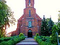 Church of Saint Catherine in Ocieka
 -
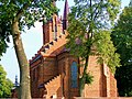 Church of Saint Catherine in Ocieka
 -
 Shrine to the Virgin Mary in Ocieka
 -
 Cemetery in Ocieka


| Seat | ||
|---|---|---|
| Other villages | ||
This Podkarpackie Voivodeship location article is a stub. You can help Wikipedia by expanding it. |
This Poland-related article is a stub. You can help Wikipedia by expanding it. |
This Ropczyce-Sędziszów County location article is a stub. You can help Wikipedia by expanding it. |
This article incorporates text from a publication now in the public domain: Chisholm, Hugh, ed. (1911). Encyclopædia Britannica (11th ed.). Cambridge University Press. {{cite encyclopedia}}: Missing or empty |title= (help)