Betioky Sud: Difference between revisions
Content deleted Content added
No edit summary |
No edit summary |
||
| Line 13: | Line 13: | ||
==Nature== |
==Nature== |
||
The [[Beza Mahafaly Reserve]] lies approx. 35 km North-East of Betioky. |
The [[Beza Mahafaly Reserve]] lies approx. 35 km North-East of Betioky Sud. |
||
==Religion== |
|||
*EEM - Eklesia Episkopaly Malagasy (Anglican Church of Madagascar)<ref>[https://dioceseoftoliara.org/fr/paroisse-betioky/ Diocese de Toliara.org]</ref> |
|||
{{coord|23|43|14|S|44|22|50|E|type:city|display=title}} |
{{coord|23|43|14|S|44|22|50|E|type:city|display=title}} |
||
Revision as of 14:44, 17 May 2021
Betioky Sud | |
|---|---|
town | |
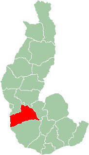
 Map of former Toliara Province showing the location of Betioky (red). | |
| Country | Madagascar |
| Region | Atsimo-Andrefana |
Betioky is a town in Atsimo-Andrefana Region, Madagascar and is crossed by the Route nationale 10. An airport serves the town.
Nature
The Beza Mahafaly Reserve lies approx. 35 km North-East of Betioky Sud.
Religion
- EEM - Eklesia Episkopaly Malagasy (Anglican Church of Madagascar)[1]

