
Lake Bronson State Park: Difference between revisions
Protected areas template added |
m Delink dates (WP:MOSUNLINKDATES) using Project:AWB |
||
| Line 18: | Line 18: | ||
| architect = |
| architect = |
||
| architecture = |
| architecture = |
||
| added = |
| added =October 25, 1989 |
||
| visitation_num = 110,975 |
| visitation_num = 110,975 |
||
| visitation_year = 2006 |
| visitation_year = 2006 |
||
Revision as of 00:58, 23 December 2009
Lake Bronson State Park WPA/Rustic Style Historic Resources | |
 | |
| Location | Off Co. Hwy. 28 E of Lake Bronson |
|---|---|
| Nearest city | Lake Bronson, Minnesota |
| Area | 3598 acres (14.5km²) |
| Visitation | 110,975 (2006) |
| MPS | Minnesota State Park CCC/WPA/Rustic Style MPS |
| NRHP reference No. | 89001659 |
| Added to NRHP | October 25, 1989 |
48°43′29″N 96°36′12″W / 48.7247004°N 96.6033741°W Lake Bronson State Park is a state park near Lake Bronson in the northwestern corner of Minnesota.
History
Kittson County has no natural lakes, which is unusual for Minnesota. In the early 1930s, during the Great Depression, Kittson County was going through a drought. Local officials decided to build a reservoir on the South Branch of Two Rivers near the city of Bronson. Supporters lobbied the state and federal government to fund the project, and in 1936, funding was finally made available. By this time, the plan had evolved into a recreation area in addition to the reservoir. Kittson County was lacking in recreation facilities, and officials realized that county residents and tourists would appreciate a park.
Construction of the reservoir started in April 1936 with crews from the Works Progress Administration. It was difficult to find a stable bedrock foundation for the dam, so crews needed to squeeze water from the "quicksand" foundation. Pumps were used to pull water from the quicksand while the dam was built. Since the sand would get wet and soft again, the pumps were not a permanent solution. Rather, the dam was designed with ten seepage pipes that drain into a drainage tunnel passing through the dam's three spillways. The dam, completed in June 1937, created a 325-acre (1.3 km2) reservoir and was well-received by local residents.
The land surrounding the new reservoir was designated a state park, and several fieldstone structures were built. The most prominent of these was a 45-foot (14 m) hexagonal stone water tower. Other structures, such as an office, a garage, a picnic shelter, and bathing facilities followed. In 1939, the city of Bronson renamed itself "Lake Bronson" to commemorate the new reservoir.
The park is now a prime recreational destination in northwest Minnesota, visited by tourists from North Dakota and southern Canada as well as Minnesotans. Fishing, swimming, canoeing, and water skiing are popular on the lake, and snowmobiling and cross-country skiing are enjoyed during the winter. The park was placed on the National Register of Historic Places in 1989.
Geology
The park is now dominated by Lake Bronson. As well as being a transition between prairie and forest lands which allows for a variety of wildlife. Thousands of years ago the area was covered by Glacial Lake Agassiz. Lake Agassiz retreated in stages leaving gravel ridges along a generally flat terrain. Streams quietly cut through these ridges and the dam that created Lake Bronson is blocking one of these ridges along the South Branch of the Two Rivers.
Images
-
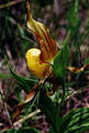 Yellow Ladyslipper at Lake Bronson State Park
 -
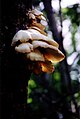 Mushroom near campground at Lake Bronson State Park


References
- Gardner, Denis P. (2004). Minnesota Treasures: Stories Behind the State's Historic Places. St. Paul, Minnesota: Minnesota Historical Society. ISBN 0-87351-471-8.
{{cite book}}: Cite has empty unknown parameter:|coauthors=(help)
External links
| Topics | |
|---|---|
| Lists by state |
|
| Lists by insular areas | |
| Lists by associated state | |
| Other areas | |
| Related | |
This Minnesota state location article is a stub. You can help Wikipedia by expanding it. |