Betioky Sud: Difference between revisions
Content deleted Content added
road |
|||
| Line 9: | Line 9: | ||
|subdivision_type1 = Region |
|subdivision_type1 = Region |
||
|subdivision_name1 = [[Atsimo-Andrefana]]}} |
|subdivision_name1 = [[Atsimo-Andrefana]]}} |
||
'''Betioky''' is a town in [[Atsimo-Andrefana]] Region, [[Madagascar]]. |
'''Betioky''' is a town in [[Atsimo-Andrefana]] Region, [[Madagascar]] and is crossed by the [[Route nationale 10 (Madagascar)|Route nationale 10]]. |
||
==Nature== |
==Nature== |
||
Revision as of 08:15, 22 May 2013
Betioky | |
|---|---|
town | |
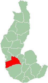
 Map of former Toliara Province showing the location of Betioky (red). | |
| Country | Madagascar |
| Region | Atsimo-Andrefana |
Betioky is a town in Atsimo-Andrefana Region, Madagascar and is crossed by the Route nationale 10.
Nature
The Beza Mahafaly Reserve lies approx. 35 km North-East of Betioky. 24°36′14″S 44°45′56″E / 24.60389°S 44.76556°E

