Nagykónyi
Nagykónyi | |
|---|---|
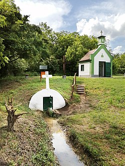
 Chapel of Saint Roch | |
| Coordinates: 46°35′39″N 18°12′03″E / 46.59417°N 18.20083°E | |
| Country | |
| County | Tolna |
| Area | |
| • Total | 47.8 km2 (18.5 sq mi) |
| Population (2011) | |
| • Total | 1,111 |
| • Density | 23/km2 (60/sq mi) |
| Time zone | UTC+1 (CET) |
| • Summer (DST) | UTC+2 (CEST) |
| Postal code | 7092 |
| Area code | 74 |
Nagykónyi is a village in Tolna county, Hungary, once settled by Danube Swabians. Around 1865 - 1880, several Danube Swabian from the Tolna settled in Slavonia, several families from Nagykónyi went to Slavonia and settled there.[1]
Twin towns – twin cities
 Ringkøbing-Skjern Municipality – Denmark since 2022
References


