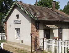
Mőcsény
| Mőcsény | ||||
|
||||
| Basic data | ||||
|---|---|---|---|---|
| State : | Hungary | |||
| Region : | Southern Transdanubia | |||
| County : | Tolna | |||
| Small area until December 31, 2012 : | Bonyhád | |||
| District since 1.1.2013 : | Bonyhád | |||
| Coordinates : | 46 ° 15 ' N , 18 ° 35' E | |||
| Area : | 12.14 km² | |||
| Residents : | 347 (Jan. 1, 2011) | |||
| Population density : | 29 inhabitants per km² | |||
| Telephone code : | (+36) 74 | |||
| Postal code : | 7163 | |||
| KSH kódja: | 33349 | |||
| Structure and administration (as of 2020) | ||||
| Community type : | local community | |||
| Structure : | Mőcsény, Palatinca, Zsibrik | |||
| Mayor : | Elemér Krachun (independent) | |||
| Postal address : | Beke utca 2 7163 Mőcsény |
|||
| Website : | ||||
| (Source: A Magyar Köztársaság helységnévkönyve 2011. január 1st at Központi statisztikai hivatal ) | ||||
Mőcsény is a Hungarian community in the county Bonyhád in Tolna county . The formerly independent municipalities of Palatinca and Zsibrik belong to Mőcsény .
Geographical location
Mőcsény is located about seven kilometers southeast of the city of Bonyhád . Neighboring communities are Cikó , Alsóbörzsöny, Grábóc, Szálka and Mórágy.
Sons and daughters of the church
- Mihály Mőcsényi (1919–2017), landscape architect and university professor
Attractions
- Roman Catholic Church Szent Péter és Pál , built in 1767 (Baroque)
- Roman Catholic Chapel Szent Anna in the Palatinca district , built in 1814, restored in 1990
- Szent Rókus statue
- World War II plaque ( I. világháborús emléktábla ) in the district of Zsibrik
traffic
Road No. 5603 runs through Mőcsény. The village is connected to the railway line from Dombóvár to Bátaszék .
Web links
- Official website ( Hungarian )
- Mőcsény near Völgységi Kistérség (Hungarian)


